
 Litoral Del Bajo San Juan
El Cantón de San Pablo
Juan Frío
Santa Barbara
El Juncal
Dibulla
Vereda Campo Alegre
San Pablo
Guaramito
Litoral Del Bajo San Juan
El Cantón de San Pablo
Juan Frío
Santa Barbara
El Juncal
Dibulla
Vereda Campo Alegre
San Pablo
Guaramito
La Flora Ecological Park on the map, Bucaramanga, Colombia
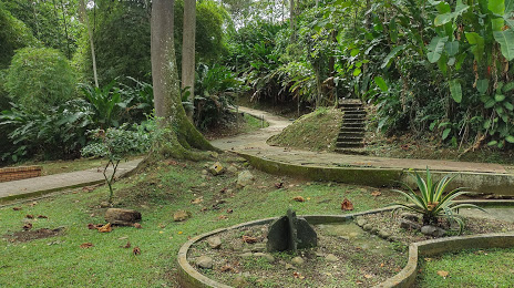
Photo
Where is located La Flora Ecological Park
La Flora Ecological Park — local attraction, which is located at La Presentación, Carrera 36 detrás del colegio La Merced y, Bucaramanga, Santander, Colombia and belongs to the category — park. Average visitor rating for this place — 4.6 (according to 4250 ratings, information from open sources and relevant for 2022).
Exact location — La Flora Ecological Park, marked on the map with a red marker.
You can get directions to La Flora Ecological Park on the map from your location.
What else is interesting in Bucaramanga? You can see all the sights if you go to the city page.
Coordinates
La Flora Ecological Park, Colombia coordinates in decimal format: latitude — 7.108334870258569, longitude — -73.1076809929918. When converted to degrees, minutes, seconds La Flora Ecological Park has the following coordinates: 7°6′30.01 north latitude and -73°6′27.65 east longitude.
Nearby cities
The largest cities that are located nearby:
- Giron — 8 km
- Floridablanca — 9 km
- Barrancabermeja — 80 km
- Cúcuta — 108 km
- San Cristobal
 (Venezuela) — 121 km
 - Sogamoso — 157 km
- Tunja — 177 km
- Ejido (Venezuela) — 259 km
- Merida (Venezuela) — 270 km
- Bello — 281 km
- Medellín — 285 km
- Envigado — 291 km
- Magangué — 293 km
- Itagüi — 294 km
- Soacha — 306 km
- Villavicencio — 335 km
- Sincelejo — 345 km
- Manizales — 348 km
- Monteria — 351 km
Distance to the capital
Distance to the capital (Bogota) is about — 299 km.