
 Manuel María Caballero
Santa Cruz Department
Pozo del Tigre
Motacucito
Colquiri
Inquisivi
Provincia de Andrés Ibáñez
Yacuíba
Tarija
Manuel María Caballero
Santa Cruz Department
Pozo del Tigre
Motacucito
Colquiri
Inquisivi
Provincia de Andrés Ibáñez
Yacuíba
Tarija
Club Social 24 de Septiembre on the map, Santa Cruz de la Sierra, Bolivia
Photo
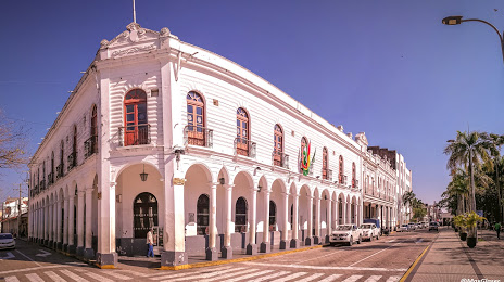
Where is located Club Social 24 de Septiembre
Club Social 24 de Septiembre — local attraction, which is located at Calle Libertad esquina Ayacucho Plaza 24 de Septiembre esquina Suroeste, Bolivia and belongs to the category — social club. Average visitor rating for this place — 4.3 (according to 534 ratings, information from open sources and relevant for 2022).
Exact location — Club Social 24 de Septiembre, marked on the map with a red marker.
You can get directions to Club Social 24 de Septiembre on the map from your location.
What else is interesting in Santa Cruz de la Sierra? You can see all the sights if you go to the city page.
Coordinates
Club Social 24 de Septiembre, Bolivia coordinates in decimal format: latitude — -17.766598701573468, longitude — -63.03502320285076. When converted to degrees, minutes, seconds Club Social 24 de Septiembre has the following coordinates: -17°45′59.76 north latitude and -63°2′6.08 east longitude.
Nearby cities
The largest cities that are located nearby:
- Sucre — 269 km
- Cochabamba — 338 km
- Potosi — 343 km
- Oruro — 433 km
- Tarija — 443 km
- San Salvador de Jujuy
 (Argentina) — 736 km
 - Tacna
 (Peru) — 762 km
 - Arica
 (Chile) — 770 km
 - Várzea Grande
 (Brazil) — 771 km
 - Cuiaba (Brazil) — 776 km
- Fist (Peru) — 780 km
- Iquique (Chile) — 785 km
- Calama (Chile) — 790 km
- Salta (Argentina) — 802 km
- Juliaca (Peru) — 803 km
- Rondonópolis (Brazil) — 900 km
- Campo Grande (Brazil) — 914 km
- Arequipa (Peru) — 920 km
- Dourados (Brazil) — 967 km
Distance to the capital
Distance to the capital (Nuestra Señora de La Paz) is about — 562 km.