
 Bel-Ha
San Jose El Alto
El Porvenir
Nueva Palestina
Santa Lucía
Chemax
La Morita
Temoac
Zacualpan
Bel-Ha
San Jose El Alto
El Porvenir
Nueva Palestina
Santa Lucía
Chemax
La Morita
Temoac
Zacualpan
Proyectos Monclova on the map, Mexico City, Mexico
Photo
Where is located Proyectos Monclova
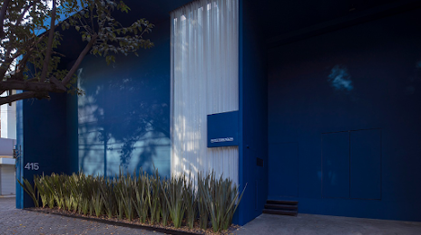
Proyectos Monclova — local attraction, which is located at Lamartine 415, Polanco, Polanco V Secc, Miguel Hidalgo, 11560 Ciudad de México, CDMX, Mexico and belongs to the category — art gallery. Average visitor rating for this place — 4.5 (according to 111 ratings, information from open sources and relevant for 2022).
Exact location — Proyectos Monclova, marked on the map with a red marker.
You can get directions to Proyectos Monclova on the map from your location.
What else is interesting in Mexico City? You can see all the sights if you go to the city page.
Coordinates
Proyectos Monclova, Mexico coordinates in decimal format: latitude — 19.430859962579607, longitude — -99.19022189285913. When converted to degrees, minutes, seconds Proyectos Monclova has the following coordinates: 19°25′51.1 north latitude and -99°11′24.8 east longitude.
Nearby cities
The largest cities that are located nearby:
- Naucalpan — 12 km
- Tlalnepantla — 13 km
- Ciudad Nezahualcóyotl — 15 km
- Chimalhuacan — 18 km
- Buenavista — 19 km
- Ciudad López Mateos — 20 km
- Ecatepec — 21 km
- Coacalco — 22 km
- Cuautitlán Izcalli — 27 km
- Texcoco — 27 km
- Ojo de Agua — 29 km
- Ixtapaluca — 30 km
- Chalco de Díaz Covarrubias — 31 km
- Metepec — 52 km
- Cuernavaca — 57 km
- Toluca — 57 km
- Jiutepec — 61 km
- Cuautla — 71 km
- Pachuca — 83 km