
 Puerto de la Duquesa
La Serna de Iguña
Pumalverde
Puentenansa
La Iglesia
Casar de Periedo
Fuengirola
Renedo de Piélagos
Villabanez
Puerto de la Duquesa
La Serna de Iguña
Pumalverde
Puentenansa
La Iglesia
Casar de Periedo
Fuengirola
Renedo de Piélagos
Villabanez
Torreon de Arroyomolinos on the map, Móstoles, Spain
Photo
Where is located Torreon de Arroyomolinos
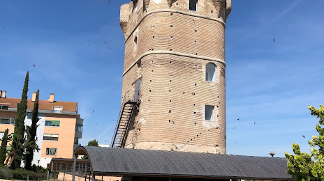
Torreon de Arroyomolinos — local attraction, which is located at C. de Serranillos, 2D, 28939 Arroyomolinos, Madrid, Spain and belongs to the category — historical landmark. Average visitor rating for this place — 4.3 (according to 209 ratings, information from open sources and relevant for 2022).
Exact location — Torreon de Arroyomolinos, marked on the map with a red marker.
You can get directions to Torreon de Arroyomolinos on the map from your location.
What else is interesting in Móstoles? You can see all the sights if you go to the city page.
Coordinates
Torreon de Arroyomolinos, Spain coordinates in decimal format: latitude — 40.268140574602306, longitude — -3.919544592374413. When converted to degrees, minutes, seconds Torreon de Arroyomolinos has the following coordinates: 40°16′5.31 north latitude and -3°55′10.36 east longitude.
Nearby cities
The largest cities that are located nearby:
- Alcorcón — 4 km
- Fuenlabrada — 7 km
- Leganés — 8 km
- Getafe — 12 km
- Alcobendas — 31 km
- Torrejón de Ardoz — 36 km
- Alcala de Henares — 46 km
- Valladolid — 163 km
- Salamanca — 166 km
- Burgos — 224 km
- Albacete — 227 km
- Logroño — 263 km
- Córdoba — 281 km
- Jaén — 281 km
- Zaragoza — 286 km
- León — 287 km
- Vitoria-Gasteiz — 296 km
- Badajoz — 311 km
- Valencia — 313 km
Distance to the capital
Distance to the capital (Madrid) is about — 25 km.