
 Los Mangos
Guangololo
Las Crucitas
Descombros
Santa Elena
Dixon Cove
El Ocotal
Bijagual
Cayo Sierra
Los Mangos
Guangololo
Las Crucitas
Descombros
Santa Elena
Dixon Cove
El Ocotal
Bijagual
Cayo Sierra
Paseo De Los Ceibeños on the map, La Ceiba, Honduras
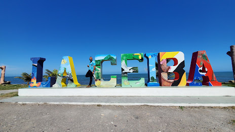
Photo
Where is located Paseo De Los Ceibeños
Paseo De Los Ceibeños — local attraction, which is located at Blvd. Los Maestro, La Ceiba, Honduras and belongs to the category — park. Average visitor rating for this place — 4.5 (according to 580 ratings, information from open sources and relevant for 2022).
Exact location — Paseo De Los Ceibeños, marked on the map with a red marker.
You can get directions to Paseo De Los Ceibeños on the map from your location.
What else is interesting in La Ceiba? You can see all the sights if you go to the city page.
Coordinates
Paseo De Los Ceibeños, Honduras coordinates in decimal format: latitude — 15.781558841428465, longitude — -86.7985207027329. When converted to degrees, minutes, seconds Paseo De Los Ceibeños has the following coordinates: 15°46′53.61 north latitude and -86°47′54.67 east longitude.
Nearby cities
The largest cities that are located nearby:
- El Progreso — 111 km
- Choloma — 120 km
- San Pedro Sula — 131 km
- San Miguel
 (El Salvador) — 291 km
 - Apopa (El Salvador) — 332 km
- Soyapango (El Salvador) — 336 km
- Chetumal
 (Mexico) — 339 km
 - Mejicanos (El Salvador) — 340 km
- San Salvador (El Salvador) — 344 km
- Chinandega
 (Nicaragua) — 349 km
 - Santa Tecla (El Salvador) — 351 km
- Santa Ana (El Salvador) — 353 km
- Lion (Nicaragua) — 369 km
- Managua (Nicaragua) — 406 km
- Guatemala City
 (Guatemala) — 416 km
 - Villa Canales (Guatemala) — 419 km
- San Juan Sacatepéquez (Guatemala) — 424 km
- Villa Nueva (Guatemala) — 425 km
- Masaya (Nicaragua) — 427 km
Distance to the capital
Distance to the capital (Tegucigalpa) is about — 194 km.