
 Bel-Ha
San Jose El Alto
El Porvenir
Nueva Palestina
Santa Lucía
Chemax
La Morita
Temoac
Zacualpan
Bel-Ha
San Jose El Alto
El Porvenir
Nueva Palestina
Santa Lucía
Chemax
La Morita
Temoac
Zacualpan
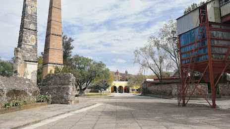
Museo Mina Valenciana 1791 on the map, Guanajuato, Mexico
Photo
Where is located Museo Mina Valenciana 1791
Museo Mina Valenciana 1791 — local attraction, which is located at Priv. Cerro del Erizo, Valenciana, 36240 Guanajuato, Gto., Mexico and belongs to the category — museum. Average visitor rating for this place — 4.7 (according to 184 ratings, information from open sources and relevant for 2022).
Exact location — Museo Mina Valenciana 1791, marked on the map with a red marker.
You can get directions to Museo Mina Valenciana 1791 on the map from your location.
What else is interesting in Guanajuato? You can see all the sights if you go to the city page.
Coordinates
Museo Mina Valenciana 1791, Mexico coordinates in decimal format: latitude — 21.040124591255964, longitude — -101.26105099283302. When converted to degrees, minutes, seconds Museo Mina Valenciana 1791 has the following coordinates: 21°2′24.45 north latitude and -101°15′39.78 east longitude.
Nearby cities
The largest cities that are located nearby:
- Irapuato — 39 km
- León — 46 km
- Salamanca — 50 km
- Celaya — 71 km
- Santiago de Querétaro — 102 km
- San Luis Potosi — 129 km
- Soledad de Graciano Sánchez — 133 km
- Aguascalientes — 143 km
- Morelia — 145 km
- San Juan del Río — 150 km
- Zamora — 156 km
- Uruapan — 196 km
- Tonalá — 210 km
- Tlaquepaque — 217 km
- Guadalajara — 220 km
- Zapopan — 227 km
- Zacatecas — 236 km
- Toluca — 255 km
- Cuautitlán Izcalli — 258 km
Distance to the capital
Distance to the capital (Mexico City) is about — 285 km.