 Pointe-à-la-Croix
Sainte-Irène, Quebec
Marsoui
Hecla
Muskrat Dam
Wunnummin Lake
Sainte-Brigitte-de-Laval
Drayton
Mauricie
Pointe-à-la-Croix
Sainte-Irène, Quebec
Marsoui
Hecla
Muskrat Dam
Wunnummin Lake
Sainte-Brigitte-de-Laval
Drayton
Mauricie
Grotto Canyon Trail Head on the map, Canmore, Canada
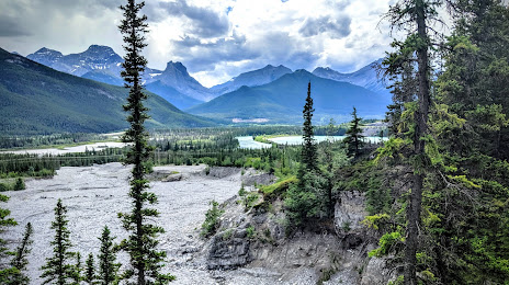
Photo
Where is located Grotto Canyon Trail Head
Grotto Canyon Trail Head — local attraction, which is located at Grotto Mountain Pond, Bighorn No. 8, AB, Canada and belongs to the category — hiking area. Average visitor rating for this place — 4.6 (according to 565 ratings, information from open sources and relevant for 2022).
Exact location — Grotto Canyon Trail Head, marked on the map with a red marker.
You can get directions to Grotto Canyon Trail Head on the map from your location.
What else is interesting in Canmore? You can see all the sights if you go to the city page.
Coordinates
Grotto Canyon Trail Head, Canada coordinates in decimal format: latitude — 51.064381482075476, longitude — -115.20372979201203. When converted to degrees, minutes, seconds Grotto Canyon Trail Head has the following coordinates: 51°3′51.77 north latitude and -115°12′13.43 east longitude.
Nearby cities
The largest cities that are located nearby:
- Calgary — 90 km
- Edmonton — 299 km
- Kelowna — 323 km
- Spokane
 (United States) — 408 km
 - Abbotsford — 552 km
- Coquitlam — 572 km
- Anmore — 574 km
- Surrey — 580 km
- Burnaby — 584 km
- Vancouver — 594 km
- Delta — 597 km
- Richmond — 600 km
- Saskatoon — 601 km
- Bellevue (United States) — 638 km
- Seattle (United States) — 646 km
- Victoria — 656 km
- Tacoma (United States) — 679 km
- Regina — 760 km
- Boise (United States) — 827 km
Distance to the capital
Distance to the capital (Ottawa) is about — 2955 km.