
 Puerto de la Duquesa
La Serna de Iguña
Pumalverde
Puentenansa
La Iglesia
Casar de Periedo
Fuengirola
Renedo de Piélagos
Villabanez
Puerto de la Duquesa
La Serna de Iguña
Pumalverde
Puentenansa
La Iglesia
Casar de Periedo
Fuengirola
Renedo de Piélagos
Villabanez
El Sotillo de Los Canónigos on the map, Palencia, Spain
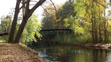
Photo
Where is located El Sotillo de Los Canónigos
El Sotillo de Los Canónigos — local attraction, which is located at C. Once Paradas, 1, 34005 Palencia, Spain and belongs to the category — park. Average visitor rating for this place — 4.4 (according to 582 ratings, information from open sources and relevant for 2022).
Exact location — El Sotillo de Los Canónigos, marked on the map with a red marker.
You can get directions to El Sotillo de Los Canónigos on the map from your location.
What else is interesting in Palencia? You can see all the sights if you go to the city page.
Coordinates
El Sotillo de Los Canónigos, Spain coordinates in decimal format: latitude — 42.01054447693373, longitude — -4.541833092320542. When converted to degrees, minutes, seconds El Sotillo de Los Canónigos has the following coordinates: 42°0′37.96 north latitude and -4°32′30.6 east longitude.
Nearby cities
The largest cities that are located nearby:
- Valladolid — 43 km
- Burgos — 77 km
- León — 107 km
- Salamanca — 149 km
- Santander — 171 km
- Vitoria-Gasteiz — 177 km
- Logroño — 177 km
- Alcobendas — 179 km
- Oviedo — 183 km
- Bilbao — 189 km
- Gijón — 191 km
- Alcorcón — 193 km
- Torrejón de Ardoz — 193 km
- Móstoles — 195 km
- Alcala de Henares — 195 km
- Leganés — 196 km
- Fuenlabrada — 200 km
- Getafe — 200 km
- Pamplona — 250 km
Distance to the capital
Distance to the capital (Madrid) is about — 191 km.