
 Bel-Ha
San Jose El Alto
El Porvenir
Nueva Palestina
Santa Lucía
Chemax
La Morita
Temoac
Zacualpan
Bel-Ha
San Jose El Alto
El Porvenir
Nueva Palestina
Santa Lucía
Chemax
La Morita
Temoac
Zacualpan
Fray Andrés de Olmos Park on the map, Tampico, Mexico
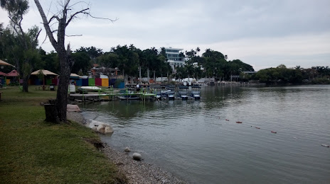
Photo
Where is located Fray Andrés de Olmos Park
Fray Andrés de Olmos Park — local attraction, which is located at Tancol SN-S PARQUE PUBLICO RECREATIVO CHAIREL, Fray Andrés de Olmos, 89229 Tampico, Tamps., Mexico and belongs to the category — park. Average visitor rating for this place — 4.7 (according to 2589 ratings, information from open sources and relevant for 2022).
Exact location — Fray Andrés de Olmos Park, marked on the map with a red marker.
You can get directions to Fray Andrés de Olmos Park on the map from your location.
What else is interesting in Tampico? You can see all the sights if you go to the city page.
Coordinates
Fray Andrés de Olmos Park, Mexico coordinates in decimal format: latitude — 22.24753027433738, longitude — -97.87894709281203. When converted to degrees, minutes, seconds Fray Andrés de Olmos Park has the following coordinates: 22°14′51.11 north latitude and -97°52′44.21 east longitude.
Nearby cities
The largest cities that are located nearby:
- Ciudad Madero — 2 km
- Tantoyuca — 105 km
- Poza Rica de Hidalgo — 193 km
- Ciudad Victoria — 211 km
- Tulancingo — 243 km
- Pachuca — 253 km
- Martínez de la Torre — 254 km
- San Juan del Río — 300 km
- Ojo de Agua — 308 km
- Xalapa — 313 km
- Soledad de Graciano Sánchez — 315 km
- Coacalco — 316 km
- Ecatepec — 316 km
- Santiago de Querétaro — 319 km
- Texcoco — 320 km
- San Luis Potosi — 320 km
- Cuautitlán Izcalli — 320 km
- Buenavista — 321 km
- Tlalnepantla — 329 km
Distance to the capital
Distance to the capital (Mexico City) is about — 339 km.