
 Bel-Ha
San Jose El Alto
El Porvenir
Nueva Palestina
Santa Lucía
Chemax
La Morita
Temoac
Zacualpan
Bel-Ha
San Jose El Alto
El Porvenir
Nueva Palestina
Santa Lucía
Chemax
La Morita
Temoac
Zacualpan
Sierra de San Juan (Nayarit) on the map, Tepic, Mexico
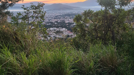
Photo
Where is located Sierra de San Juan (Nayarit)
Sierra de San Juan (Nayarit) — local attraction, which is located at 63509 Nayarit, Mexico and belongs to the category — nature preserve. Average visitor rating for this place — 4.9 (according to 13 ratings, information from open sources and relevant for 2022).
Exact location — Sierra de San Juan (Nayarit), marked on the map with a red marker.
You can get directions to Sierra de San Juan (Nayarit) on the map from your location.
What else is interesting in Tepic? You can see all the sights if you go to the city page.
Coordinates
Sierra de San Juan (Nayarit), Mexico coordinates in decimal format: latitude — 21.497121608299175, longitude — -104.89935169282528. When converted to degrees, minutes, seconds Sierra de San Juan (Nayarit) has the following coordinates: 21°29′49.64 north latitude and -104°53′57.67 east longitude.
Nearby cities
The largest cities that are located nearby:
- Puerto Vallarta — 100 km
- Zapopan — 178 km
- Guadalajara — 185 km
- Tlaquepaque — 190 km
- Tonalá — 197 km
- Mazatlán — 247 km
- Aguascalientes — 270 km
- Manzanillo — 271 km
- Zacatecas — 274 km
- Fresnillo — 277 km
- Colima — 278 km
- Durango — 280 km
- Zamora — 319 km
- León — 334 km
- Uruapan — 377 km
- Irapuato — 377 km
- Salamanca — 396 km
- San Luis Potosi — 407 km
- Soledad de Graciano Sánchez — 412 km
Distance to the capital
Distance to the capital (Mexico City) is about — 643 km.