
 Belém
Maranguape
Paranaguá
Paranaguá
Monte Alegre
Alvorada de Minas
Bragança
Laguna
Ibiporã
Belém
Maranguape
Paranaguá
Paranaguá
Monte Alegre
Alvorada de Minas
Bragança
Laguna
Ibiporã
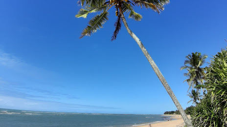
Beach Clears Fire (Praia do Apaga Fogo) on the map, Porto Seguro, Brazil
Photo
Where is located Beach Clears Fire (Praia do Apaga Fogo)
Beach Clears Fire (Praia do Apaga Fogo) — local attraction, which is located at no data and belongs to the category — -. Average visitor rating for this place — 4.6 (according to 495 ratings, information from open sources and relevant for 2022).
Exact location — Beach Clears Fire (Praia do Apaga Fogo), marked on the map with a red marker.
You can get directions to Beach Clears Fire (Praia do Apaga Fogo) on the map from your location.
What else is interesting in Porto Seguro? You can see all the sights if you go to the city page.
Coordinates
Beach Clears Fire (Praia do Apaga Fogo), Brazil coordinates in decimal format: latitude — -16.435299122993076, longitude — -39.07446496267876. When converted to degrees, minutes, seconds Beach Clears Fire (Praia do Apaga Fogo) has the following coordinates: -16°26′7.08 north latitude and -39°4′28.07 east longitude.
Nearby cities
The largest cities that are located nearby:
- Ilhéus — 183 km
- Itabuna — 185 km
- Vitória da Conquista — 258 km
- Teófilo Otoni — 301 km
- Jequié — 306 km
- Linhares — 342 km
- Colatina — 379 km
- Salvador — 389 km
- Lauro de Freitas — 402 km
- Valadares Governor — 403 km
- Camaçari — 422 km
- Serra — 427 km
- Cariacica — 445 km
- Vila Velha — 450 km
- Feira de Santana — 463 km
- Alagoinhas — 482 km
- Guarapari — 491 km
- Coronel Fabriciano — 503 km
- Montes Claros — 508 km