
 Belém
Maranguape
Paranaguá
Paranaguá
Monte Alegre
Alvorada de Minas
Bragança
Laguna
Ibiporã
Belém
Maranguape
Paranaguá
Paranaguá
Monte Alegre
Alvorada de Minas
Bragança
Laguna
Ibiporã
Parque Estadual do Utinga Camillo Vianna on the map, Ananindeua, Brazil
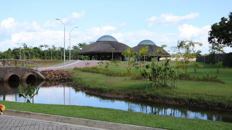
Photo
Where is located Parque Estadual do Utinga Camillo Vianna
Parque Estadual do Utinga Camillo Vianna — local attraction, which is located at Av. João Paulo II, S/N - Curió Utinga, Belém - PA, 66610-770, Brazil and belongs to the category — state park. Average visitor rating for this place — 4.7 (according to 16304 ratings, information from open sources and relevant for 2022).
Exact location — Parque Estadual do Utinga Camillo Vianna, marked on the map with a red marker.
You can get directions to Parque Estadual do Utinga Camillo Vianna on the map from your location.
What else is interesting in Ananindeua? You can see all the sights if you go to the city page.
Coordinates
Parque Estadual do Utinga Camillo Vianna, Brazil coordinates in decimal format: latitude — -1.4194128487001312, longitude — -48.41813300272097. When converted to degrees, minutes, seconds Parque Estadual do Utinga Camillo Vianna has the following coordinates: -1°25′9.89 north latitude and -48°25′5.28 east longitude.
Nearby cities
The largest cities that are located nearby:
- Belém — 16 km
- Castanhal — 51 km
- Macapá — 336 km
- Marabá — 452 km
- Imperatriz — 470 km
- São Luís — 470 km
- Araguaína — 645 km
- Caxias — 674 km
- Santarém — 709 km
- Timon — 737 km
- Teresina — 739 km
- Parnaíba — 749 km
- Palmas — 982 km
- Paramaribo
 (Suriname) — 1096 km
 - Caucaia — 1103 km
- Maracanaú — 1110 km
- Fortaleza — 1118 km
- Juazeiro do Norte — 1187 km
- Petrolina — 1235 km