
 Belém
Maranguape
Paranaguá
Paranaguá
Monte Alegre
Alvorada de Minas
Bragança
Laguna
Ibiporã
Belém
Maranguape
Paranaguá
Paranaguá
Monte Alegre
Alvorada de Minas
Bragança
Laguna
Ibiporã
Praia do Ouvidor on the map, Garopaba, Brazil
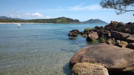
Photo
Where is located Praia do Ouvidor
Praia do Ouvidor — local attraction, which is located at Estr. Ouvidor, 1770 - Ibiraquera, Garopaba - SC, 88780-000, Brazil and belongs to the category — public beach. Average visitor rating for this place — 4.8 (according to 340 ratings, information from open sources and relevant for 2022).
Exact location — Praia do Ouvidor, marked on the map with a red marker.
You can get directions to Praia do Ouvidor on the map from your location.
What else is interesting in Garopaba? You can see all the sights if you go to the city page.
Coordinates
Praia do Ouvidor, Brazil coordinates in decimal format: latitude — -28.1131730015981, longitude — -48.641112502404134. When converted to degrees, minutes, seconds Praia do Ouvidor has the following coordinates: -28°6′47.42 north latitude and -48°38′28.01 east longitude.
Nearby cities
The largest cities that are located nearby:
- Palhoça — 42 km
- São José — 46 km
- Florianópolis — 48 km
- Criciúma — 102 km
- Itajaí — 124 km
- Blumenau — 131 km
- Lages — 169 km
- Jaraguá do Sul — 177 km
- Joinville — 192 km
- Caxias do Sul — 277 km
- Paranaguá — 278 km
- Araucária — 281 km
- São José dos Pinhais — 282 km
- Pinhais — 291 km
- Curitiba — 294 km
- Novo Hamburgo — 303 km
- Colombo — 308 km
- São Leopoldo — 309 km
- Gravataí — 311 km