
 Omoa
El Zapote
Cofradía
Trinidad de Quebrada
Las Lajas
La Paz
San Jose
Olanchito
Petoa
San Manuel
Zambrano
Santa Ana
Tela
Santa Lucia
Valle de Angeles
Villa de San Francisco
Teupasenti
La Jutosa
Villanueva
Omoa
El Zapote
Cofradía
Trinidad de Quebrada
Las Lajas
La Paz
San Jose
Olanchito
Petoa
San Manuel
Zambrano
Santa Ana
Tela
Santa Lucia
Valle de Angeles
Villa de San Francisco
Teupasenti
La Jutosa
Villanueva
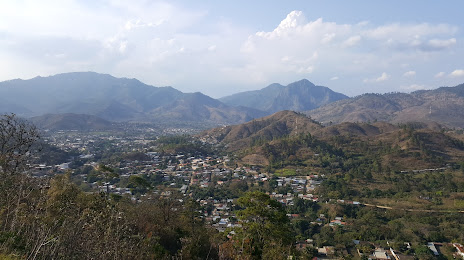
Danli on the map, Honduras
Where is located Danli
Exact location — Danli, El Paraiso, Honduras, marked on the map with a red marker.
Coordinates
Danli, Honduras coordinates in decimal format: latitude — 14.0410953, longitude — -86.5703554. When converted to degrees, minutes, seconds Danli has the following coordinates: 14°2′27.94 north latitude and -86°34′13.28 east longitude.
Population
Danli, El Paraiso, Honduras, according to our data the population is — 44,805 residents, which is about 0.5% of the total population of the country (Honduras).
Comparison of the population on the graph:
Exact time
Time zone for this location Danli — UTC -6 America/Tegucigalpa. Exact time — saturday, 5 may 2024 year, 15 h. 47 minutes.
Sunrise and sunset
Danli, sunrise and sunset data for a date — saturday 4.05.2024.
| Sunrise | Sunset | Day (duration) |
|---|---|---|
| 05:25 -0 minutes | 18:00 -0 minutes | 12 h. 36 minutes. -0 minutes |
You can control the scale of the map using the auxiliary tools to find out exactly where it is located Danli. When you change the scale of the map, the width of the ruler also changes (in kilometers and miles).
Nearby cities
The largest cities that are located nearby:
- Chinandega
 (Nicaragua) — 168 km
 - Lion (Nicaragua) — 181 km
- San Miguel
 (El Salvador) — 184 km
 - La Ceiba — 193 km
- El Progreso — 199 km
- Managua (Nicaragua) — 213 km
- San Pedro Sula — 224 km
- Choloma — 226 km
- Masaya (Nicaragua) — 235 km
- Soyapango (El Salvador) — 278 km
- Apopa (El Salvador) — 281 km
- Mejicanos (El Salvador) — 286 km
- San Salvador (El Salvador) — 287 km
- Santa Tecla (El Salvador) — 295 km
- Santa Ana (El Salvador) — 321 km
- Villa Canales
 (Guatemala) — 425 km
 - Guatemala City (Guatemala) — 429 km
- Villa Nueva (Guatemala) — 433 km
- San Juan Sacatepéquez (Guatemala) — 442 km
Distance to neighboring capitals:
- Managua (Nicaragua) — 215 km
- San Salvador (El Salvador) — 289 km
- Belmopan
 (Belize) — 428 km
 - Guatemala City (Guatemala) — 432 km
- San Jose
 (Costa Rica) — 531 km
 - Mexico City
 (Mexico) — 1466 km
Attractions
Distance to the capital
Distance to the capital (Tegucigalpa) is about — 70 km.