
 Litoral Del Bajo San Juan
El Cantón de San Pablo
Juan Frío
Santa Barbara
El Juncal
Dibulla
Vereda Campo Alegre
San Pablo
Guaramito
Litoral Del Bajo San Juan
El Cantón de San Pablo
Juan Frío
Santa Barbara
El Juncal
Dibulla
Vereda Campo Alegre
San Pablo
Guaramito
Simón Bolívar Park on the map, Cúcuta, Colombia
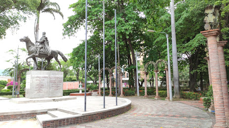
Photo
Where is located Simón Bolívar Park
Simón Bolívar Park — local attraction, which is located at Cl. 6 #Este-2a, Cúcuta, Norte de Santander, Colombia and belongs to the category — park. Average visitor rating for this place — 4.3 (according to 1264 ratings, information from open sources and relevant for 2022).
Exact location — Simón Bolívar Park, marked on the map with a red marker.
You can get directions to Simón Bolívar Park on the map from your location.
What else is interesting in Cúcuta? You can see all the sights if you go to the city page.
Coordinates
Simón Bolívar Park, Colombia coordinates in decimal format: latitude — 7.893670658435339, longitude — -72.48997810285478. When converted to degrees, minutes, seconds Simón Bolívar Park has the following coordinates: 7°53′37.21 north latitude and -72°29′23.92 east longitude.
Nearby cities
The largest cities that are located nearby:
- San Cristobal
 (Venezuela) — 33 km
 - Bucaramanga — 108 km
- Floridablanca — 111 km
- Giron — 116 km
- Ejido (Venezuela) — 156 km
- Merida (Venezuela) — 168 km
- Barrancabermeja — 174 km
- Sogamoso — 244 km
- Barinas (Venezuela) — 261 km
- Tunja — 275 km
- Magangué — 288 km
- Valledupar — 298 km
- Cabimas (Venezuela) — 299 km
- Maracaibo (Venezuela) — 318 km
- Guanare (Venezuela) — 329 km
- Sincelejo — 353 km
- Bello — 377 km
- Medellín — 381 km
- Monteria — 381 km
Distance to the capital
Distance to the capital (Bogota) is about — 406 km.