
 La Armonía
Timote
Cruz de Piedra
Villa Concepción del Tio
Manantiales
Colonia Italiana
Los Tigres
Puerto Leoni
Campo Santo
La Armonía
Timote
Cruz de Piedra
Villa Concepción del Tio
Manantiales
Colonia Italiana
Los Tigres
Puerto Leoni
Campo Santo
La Aripuca on the map, Puerto Iguazú, Argentina
Photo
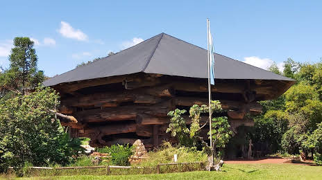
Where is located La Aripuca
La Aripuca — local attraction, which is located at RN12, Puerto Iguazú, Misiones, Argentina and belongs to the category — ecological park. Average visitor rating for this place — 4.4 (according to 10380 ratings, information from open sources and relevant for 2022).
Exact location — La Aripuca, marked on the map with a red marker.
You can get directions to La Aripuca on the map from your location.
What else is interesting in Puerto Iguazú? You can see all the sights if you go to the city page.
Coordinates
La Aripuca, Argentina coordinates in decimal format: latitude — -25.618557354267573, longitude — -54.55846280261534. When converted to degrees, minutes, seconds La Aripuca has the following coordinates: -25°37′6.81 north latitude and -54°33′30.47 east longitude.
Nearby cities
The largest cities that are located nearby:
- Foz do Iguaçu
 (Brazil) — 9 km
 - Ciudad del Este
 (Paraguay) — 10 km
 - Cascavel (Brazil) — 133 km
- Posadas — 234 km
- Chapecó (Brazil) — 255 km
- Capiata (Paraguay) — 288 km
- Luque (Paraguay) — 293 km
- San Lorenzo (Paraguay) — 295 km
- Fernando De La Mora (Paraguay) — 298 km
- Lambare (Paraguay) — 304 km
- Asuncion (Paraguay) — 308 km
- Guarapuava (Brazil) — 312 km
- Maringá (Brazil) — 360 km
- Passo Fundo (Brazil) — 362 km
- Formosa — 363 km
- Dourados (Brazil) — 374 km
- Apucarana (Brazil) — 388 km
- Santa Maria (Brazil) — 458 km
- Corrientes — 467 km
Distance to the capital
Distance to the capital (Buenos Aires) is about — 1065 km.