
 Józefów nad Wisłą
Gorzyce Wielkie
Rogówek
Sromowce Niżne
Wyszków County
Kruszewo
Jantar
Sady Górne
Nagoszewo
Józefów nad Wisłą
Gorzyce Wielkie
Rogówek
Sromowce Niżne
Wyszków County
Kruszewo
Jantar
Sady Górne
Nagoszewo
Stadtpark Volkspark (Park Miejski) on the map, Legnica, Poland
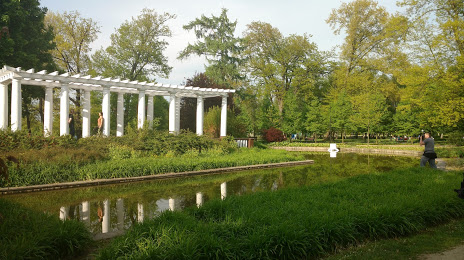
Photo
Where is located Stadtpark Volkspark (Park Miejski)
Stadtpark Volkspark (Park Miejski) — local attraction, which is located at Biała, 59-220 Legnica, Poland and belongs to the category — city park. Average visitor rating for this place — 4.6 (according to 3748 ratings, information from open sources and relevant for 2022).
Exact location — Stadtpark Volkspark (Park Miejski), marked on the map with a red marker.
You can get directions to Stadtpark Volkspark (Park Miejski) on the map from your location.
What else is interesting in Legnica? You can see all the sights if you go to the city page.
Coordinates
Stadtpark Volkspark (Park Miejski), Poland coordinates in decimal format: latitude — 51.202603367850855, longitude — 16.168528898125295. When converted to degrees, minutes, seconds Stadtpark Volkspark (Park Miejski) has the following coordinates: 51°12′9.37 north latitude and 16°10′6.7 east longitude.
Nearby cities
The largest cities that are located nearby:
- Walbrzych — 48 km
- Wrocław — 62 km
- Zielona Gora — 92 km
- Opole — 137 km
- Cottbus
 (Germany) — 139 km
 - Poznań — 142 km
- Kalisz — 146 km
- Dresden (Germany) — 169 km
- Prague
 (Czech Republic) — 175 km
 - Gorzów Wielkopolski — 180 km
- Olomouc (Czech Republic) — 195 km
- Gliwice — 204 km
- Rybnik — 209 km
- Zabrze — 210 km
- Częstochowa — 212 km
- Ostrava (Czech Republic) — 215 km
- Bytom — 217 km
- Ruda Slaska — 218 km
- Chorzow — 222 km
Distance to the capital
Distance to the capital (Warsaw) is about — 353 km.