
 Józefów nad Wisłą
Gorzyce Wielkie
Rogówek
Sromowce Niżne
Wyszków County
Kruszewo
Jantar
Sady Górne
Nagoszewo
Józefów nad Wisłą
Gorzyce Wielkie
Rogówek
Sromowce Niżne
Wyszków County
Kruszewo
Jantar
Sady Górne
Nagoszewo
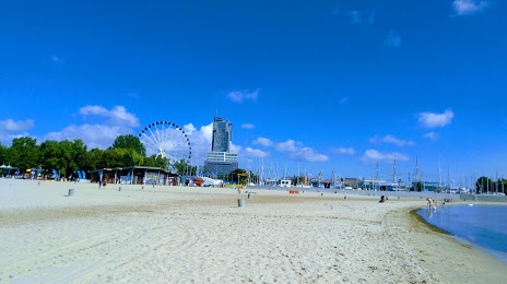
Gdynia City Beach on the map, Sopot, Poland
Photo
Where is located Gdynia City Beach
Gdynia City Beach — local attraction, which is located at Gdynia, Poland and belongs to the category — public beach. Average visitor rating for this place — 4.6 (according to 10906 ratings, information from open sources and relevant for 2022).
Exact location — Gdynia City Beach, marked on the map with a red marker.
You can get directions to Gdynia City Beach on the map from your location.
What else is interesting in Sopot? You can see all the sights if you go to the city page.
Coordinates
Gdynia City Beach, Poland coordinates in decimal format: latitude — 54.50537267600938, longitude — 18.471933478013526. When converted to degrees, minutes, seconds Gdynia City Beach has the following coordinates: 54°30′19.34 north latitude and 18°28′18.96 east longitude.
Nearby cities
The largest cities that are located nearby:
- Gdynia — 9 km
- Gdańsk — 11 km
- Elblag — 63 km
- Kaliningrad
 (Russia) — 129 km
 - Olsztyn — 145 km
- Bydgoszcz — 150 km
- Koszalin — 157 km
- Torun — 158 km
- Wloclawek — 201 km
- Klaipėda
 (Lithuania) — 213 km
 - Plock — 223 km
- Poznań — 251 km
- Szczecin — 287 km
- Gorzów Wielkopolski — 292 km
- Kalisz — 297 km
- Łódź — 303 km
- Šiauliai (Lithuania) — 338 km
- Bialystok — 338 km
- Kaunas (Lithuania) — 343 km
Distance to the capital
Distance to the capital (Warsaw) is about — 304 km.