
 Józefów nad Wisłą
Gorzyce Wielkie
Rogówek
Sromowce Niżne
Wyszków County
Kruszewo
Jantar
Sady Górne
Nagoszewo
Józefów nad Wisłą
Gorzyce Wielkie
Rogówek
Sromowce Niżne
Wyszków County
Kruszewo
Jantar
Sady Górne
Nagoszewo
The ruins of the Castle Kamieniec (Zamek Kamieniec) on the map, Krosno, Poland
Photo
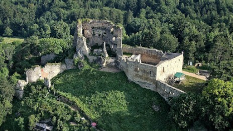
Where is located The ruins of the Castle Kamieniec (Zamek Kamieniec)
The ruins of the Castle Kamieniec (Zamek Kamieniec) — local attraction, which is located at Podzamcze B/N, 38-420 Korczyna, Poland and belongs to the category — castle. Average visitor rating for this place — 4.4 (according to 2754 ratings, information from open sources and relevant for 2022).
Exact location — The ruins of the Castle Kamieniec (Zamek Kamieniec), marked on the map with a red marker.
You can get directions to The ruins of the Castle Kamieniec (Zamek Kamieniec) on the map from your location.
What else is interesting in Krosno? You can see all the sights if you go to the city page.
Coordinates
The ruins of the Castle Kamieniec (Zamek Kamieniec), Poland coordinates in decimal format: latitude — 49.7425783133027, longitude — 21.786660998072403. When converted to degrees, minutes, seconds The ruins of the Castle Kamieniec (Zamek Kamieniec) has the following coordinates: 49°44′33.28 north latitude and 21°47′11.98 east longitude.
Nearby cities
The largest cities that are located nearby:
- Rzeszow — 43 km
- Tarnow — 66 km
- Košice
 (Slovakia) — 113 km
 - Uzhhorod
 (Ukraine) — 123 km
 - Kraków — 136 km
- Kielce — 153 km
- Lublin — 182 km
- Miskolc
 (Hungary) — 190 km
 - Nyíregyháza (Hungary) — 192 km
- Bielsko-Biala — 194 km
- Dabrowa Gornicza — 195 km
- Radom — 195 km
- Sosnowiec — 200 km
- Katowice — 204 km
- Chorzow — 210 km
- Bytom — 214 km
- Ruda Slaska — 215 km
- Zabrze — 222 km
- Częstochowa — 223 km
Distance to the capital
Distance to the capital (Warsaw) is about — 282 km.