
 Józefów nad Wisłą
Gorzyce Wielkie
Rogówek
Sromowce Niżne
Wyszków County
Kruszewo
Jantar
Sady Górne
Nagoszewo
Józefów nad Wisłą
Gorzyce Wielkie
Rogówek
Sromowce Niżne
Wyszków County
Kruszewo
Jantar
Sady Górne
Nagoszewo
Ratusz w Zielonej Górze on the map, Zielona Gora, Poland
Photo
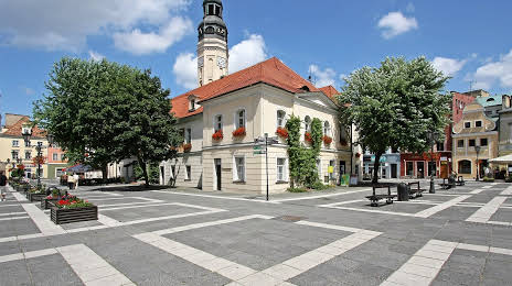
Where is located Ratusz w Zielonej Górze
Ratusz w Zielonej Górze — local attraction, which is located at Stary Rynek 1, 65-068 Zielona Góra, Poland and belongs to the category — city or town hall. Average visitor rating for this place — 4.6 (according to 776 ratings, information from open sources and relevant for 2022).
Exact location — Ratusz w Zielonej Górze, marked on the map with a red marker.
You can get directions to Ratusz w Zielonej Górze on the map from your location.
What else is interesting in Zielona Gora? You can see all the sights if you go to the city page.
Coordinates
Ratusz w Zielonej Górze, Poland coordinates in decimal format: latitude — 51.93822280750652, longitude — 15.505203998152348. When converted to degrees, minutes, seconds Ratusz w Zielonej Górze has the following coordinates: 51°56′17.6 north latitude and 15°30′18.73 east longitude.
Nearby cities
The largest cities that are located nearby:
- Cottbus
 (Germany) — 83 km
 - Gorzów Wielkopolski — 90 km
- Legnica — 92 km
- Poznań — 109 km
- Walbrzych — 138 km
- Wrocław — 140 km
- Berlin (Germany) — 155 km
- Berlin (Germany) — 155 km
- Dresden (Germany) — 157 km
- Potsdam (Germany) — 172 km
- Szczecin — 177 km
- Kalisz — 177 km
- Bydgoszcz — 212 km
- Chemnitz (Germany) — 218 km
- Prague
 (Czech Republic) — 219 km
 - Opole — 219 km
- Leipzig (Germany) — 226 km
- Torun — 238 km
- Wloclawek — 252 km
Distance to the capital
Distance to the capital (Warsaw) is about — 378 km.