
 Puerto de la Duquesa
La Serna de Iguña
Pumalverde
Puentenansa
La Iglesia
Casar de Periedo
Fuengirola
Renedo de Piélagos
Villabanez
Puerto de la Duquesa
La Serna de Iguña
Pumalverde
Puentenansa
La Iglesia
Casar de Periedo
Fuengirola
Renedo de Piélagos
Villabanez
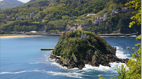
Isla de Santa Clara Lighthouse on the map, San Sebastián, Spain
Photo
Where is located Isla de Santa Clara Lighthouse
Isla de Santa Clara Lighthouse — local attraction, which is located at Kalea Isla de Santa Clara, 2, 20003 Donostia, Gipuzkoa, Spain and belongs to the category — tourist attraction. Average visitor rating for this place — 4.7 (according to 317 ratings, information from open sources and relevant for 2022).
Exact location — Isla de Santa Clara Lighthouse, marked on the map with a red marker.
You can get directions to Isla de Santa Clara Lighthouse on the map from your location.
What else is interesting in San Sebastián? You can see all the sights if you go to the city page.
Coordinates
Isla de Santa Clara Lighthouse, Spain coordinates in decimal format: latitude — 43.322067504429086, longitude — -1.9982420019880411. When converted to degrees, minutes, seconds Isla de Santa Clara Lighthouse has the following coordinates: 43°19′19.44 north latitude and -1°59′53.67 east longitude.
Nearby cities
The largest cities that are located nearby:
- Pamplona — 62 km
- Vitoria-Gasteiz — 76 km
- Bilbao — 77 km
- Logroño — 102 km
- Santander — 148 km
- Burgos — 177 km
- Bordeaux
 (France) — 201 km
 - Zaragoza — 205 km
- Toulouse (France) — 276 km
- Lleida — 286 km
- Valladolid — 292 km
- Gijón — 296 km
- León — 302 km
- Oviedo — 311 km
- Alcala de Henares — 334 km
- Alcobendas — 337 km
- Torrejón de Ardoz — 340 km
- Tarragona — 362 km
- Leganés — 363 km
Distance to the capital
Distance to the capital (Madrid) is about — 353 km.