
 Puerto de la Duquesa
La Serna de Iguña
Pumalverde
Puentenansa
La Iglesia
Casar de Periedo
Fuengirola
Renedo de Piélagos
Villabanez
Puerto de la Duquesa
La Serna de Iguña
Pumalverde
Puentenansa
La Iglesia
Casar de Periedo
Fuengirola
Renedo de Piélagos
Villabanez
Sierra de Bernia y Ferrer on the map, Altea, Spain
Photo
Where is located Sierra de Bernia y Ferrer
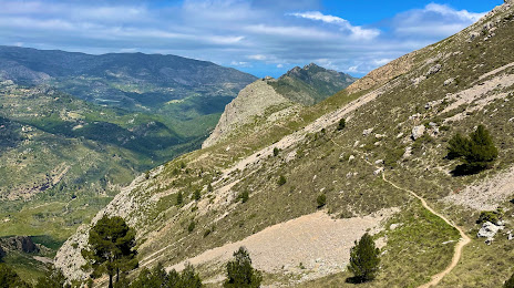
Sierra de Bernia y Ferrer — local attraction, which is located at Alicante, Spain and belongs to the category — hiking area. Average visitor rating for this place — 4.7 (according to 1564 ratings, information from open sources and relevant for 2022).
Exact location — Sierra de Bernia y Ferrer, marked on the map with a red marker.
You can get directions to Sierra de Bernia y Ferrer on the map from your location.
What else is interesting in Altea? You can see all the sights if you go to the city page.
Coordinates
Sierra de Bernia y Ferrer, Spain coordinates in decimal format: latitude — 38.65904620044271, longitude — -0.03433419042392734. When converted to degrees, minutes, seconds Sierra de Bernia y Ferrer has the following coordinates: 38°39′32.57 north latitude and -0°2′3.6 east longitude.
Nearby cities
The largest cities that are located nearby:
- Valencia — 100 km
- Murcia — 116 km
- Cartagena — 136 km
- Albacete — 162 km
- Palma — 253 km
- Almería — 290 km
- Chlef
 (Algeria) — 296 km
 - Tarragona — 298 km
- Relizane (Algeria) — 322 km
- Oran (Algeria) — 326 km
- Lleida — 338 km
- Jaén — 339 km
- Algiers (Algeria) — 342 km
- Zaragoza — 344 km
- Alcala de Henares — 348 km
- Granada — 350 km
- Torrejón de Ardoz — 354 km
- L'Hospitalet de Llobregat — 354 km
- Médéa (Algeria) — 359 km
Distance to the capital
Distance to the capital (Madrid) is about — 370 km.