
 Puerto de la Duquesa
La Serna de Iguña
Pumalverde
Puentenansa
La Iglesia
Casar de Periedo
Fuengirola
Renedo de Piélagos
Villabanez
Puerto de la Duquesa
La Serna de Iguña
Pumalverde
Puentenansa
La Iglesia
Casar de Periedo
Fuengirola
Renedo de Piélagos
Villabanez
The Magic Forest on the map, Alcorcón, Spain
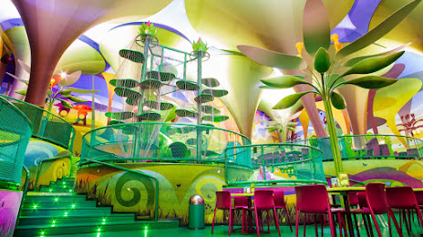
Photo
Where is located The Magic Forest
The Magic Forest — local attraction, which is located at Ciudad de la Imagen, C. Edgar Neville, s/n, 28223 Pozuelo de Alarcón, Madrid, Spain and belongs to the category — playground. Average visitor rating for this place — 4.1 (according to 1180 ratings, information from open sources and relevant for 2022).
Exact location — The Magic Forest, marked on the map with a red marker.
You can get directions to The Magic Forest on the map from your location.
What else is interesting in Alcorcón? You can see all the sights if you go to the city page.
Coordinates
The Magic Forest, Spain coordinates in decimal format: latitude — 40.393846023548626, longitude — -3.7978140022382814. When converted to degrees, minutes, seconds The Magic Forest has the following coordinates: 40°23′37.85 north latitude and -3°47′52.13 east longitude.
Nearby cities
The largest cities that are located nearby:
- Móstoles — 4 km
- Leganés — 5 km
- Fuenlabrada — 7 km
- Getafe — 9 km
- Alcobendas — 26 km
- Torrejón de Ardoz — 32 km
- Alcala de Henares — 42 km
- Valladolid — 162 km
- Salamanca — 168 km
- Burgos — 221 km
- Albacete — 226 km
- Logroño — 260 km
- Zaragoza — 282 km
- Jaén — 284 km
- Córdoba — 284 km
- León — 286 km
- Vitoria-Gasteiz — 293 km
- Valencia — 310 km
- Badajoz — 315 km
Distance to the capital
Distance to the capital (Madrid) is about — 8 km.