
 Maureville
Samoëns
Gréning
Toulouse
Volx
Goudet
Méhoncourt
Saint-Hymer
Pontcarré
Maureville
Samoëns
Gréning
Toulouse
Volx
Goudet
Méhoncourt
Saint-Hymer
Pontcarré
Park Rhônelle on the map, Saint-Saulve, France
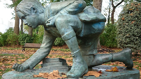
Photo
Where is located Park Rhônelle
Park Rhônelle — local attraction, which is located at Bd Carpeaux, 59300 Valenciennes, France and belongs to the category — park. Average visitor rating for this place — 4.3 (according to 1776 ratings, information from open sources and relevant for 2022).
Exact location — Park Rhônelle, marked on the map with a red marker.
You can get directions to Park Rhônelle on the map from your location.
What else is interesting in Saint-Saulve? You can see all the sights if you go to the city page.
Coordinates
Park Rhônelle, France coordinates in decimal format: latitude — 50.35283005182281, longitude — 3.527476298252765. When converted to degrees, minutes, seconds Park Rhônelle has the following coordinates: 50°21′10.19 north latitude and 3°31′38.91 east longitude.
Nearby cities
The largest cities that are located nearby:
- Lille — 45 km
- Charleroi
 (Belgium) — 63 km
 - Brussels (Belgium) — 77 km
- Namur (Belgium) — 93 km
- Amiens — 104 km
- Antwerp (Belgium) — 111 km
- Reims — 128 km
- Liège (Belgium) — 145 km
- Breda
 (Netherlands) — 158 km
 - Maastricht (Netherlands) — 158 km
- Tilburg (Netherlands) — 169 km
- Eindhoven (Netherlands) — 177 km
- Dordrecht (Netherlands) — 177 km
- Aachen
 (Germany) — 182 km
 - Rotterdam (Netherlands) — 183 km
- 's-Hertogenbosch (Netherlands) — 189 km
- Boulogne-Billancourt — 194 km
- The Hague (Netherlands) — 195 km
- Zoetermeer (Netherlands) — 197 km
Distance to the capital
Distance to the capital (Paris) is about — 187 km.