
 Józefów nad Wisłą
Gorzyce Wielkie
Rogówek
Sromowce Niżne
Wyszków County
Kruszewo
Jantar
Sady Górne
Nagoszewo
Józefów nad Wisłą
Gorzyce Wielkie
Rogówek
Sromowce Niżne
Wyszków County
Kruszewo
Jantar
Sady Górne
Nagoszewo
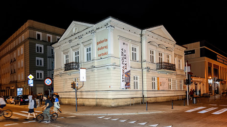
Muzeum Częstochowskie - Galeria Dobrej Sztuki on the map, Częstochowa, Poland
Photo
Where is located Muzeum Częstochowskie - Galeria Dobrej Sztuki
Muzeum Częstochowskie - Galeria Dobrej Sztuki — local attraction, which is located at Aleja Najświętszej Maryi Panny 47, 42-200 Częstochowa, Poland and belongs to the category — museum. Average visitor rating for this place — 4.6 (according to 25 ratings, information from open sources and relevant for 2022).
Exact location — Muzeum Częstochowskie - Galeria Dobrej Sztuki, marked on the map with a red marker.
You can get directions to Muzeum Częstochowskie - Galeria Dobrej Sztuki on the map from your location.
What else is interesting in Częstochowa? You can see all the sights if you go to the city page.
Coordinates
Muzeum Częstochowskie - Galeria Dobrej Sztuki, Poland coordinates in decimal format: latitude — 50.811795473016055, longitude — 19.11204312529398. When converted to degrees, minutes, seconds Muzeum Częstochowskie - Galeria Dobrej Sztuki has the following coordinates: 50°48′42.46 north latitude and 19°6′43.36 east longitude.
Nearby cities
The largest cities that are located nearby:
- Bytom — 53 km
- Dabrowa Gornicza — 54 km
- Chorzow — 58 km
- Sosnowiec — 58 km
- Zabrze — 59 km
- Katowice — 61 km
- Ruda Slaska — 64 km
- Gliwice — 65 km
- Opole — 85 km
- Rybnik — 88 km
- Kraków — 101 km
- Kielce — 105 km
- Łódź — 107 km
- Bielsko-Biala — 109 km
- Ostrava
 (Czech Republic) — 125 km
 - Kalisz — 127 km
- Wrocław — 148 km
- Radom — 154 km
- Tarnow — 159 km
Distance to the capital
Distance to the capital (Warsaw) is about — 205 km.