
 Józefów nad Wisłą
Gorzyce Wielkie
Rogówek
Sromowce Niżne
Wyszków County
Kruszewo
Jantar
Sady Górne
Nagoszewo
Józefów nad Wisłą
Gorzyce Wielkie
Rogówek
Sromowce Niżne
Wyszków County
Kruszewo
Jantar
Sady Górne
Nagoszewo
Schloss Erdmannsdorf on the map, Jelenia Góra, Poland
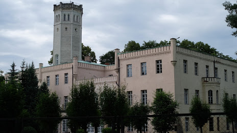
Photo
Where is located Schloss Erdmannsdorf
Schloss Erdmannsdorf — local attraction, which is located at Sułkowskiego 4, 58-533 Mysłakowice, Poland and belongs to the category — monument. Average visitor rating for this place — 4.1 (according to 446 ratings, information from open sources and relevant for 2022).
Exact location — Schloss Erdmannsdorf, marked on the map with a red marker.
You can get directions to Schloss Erdmannsdorf on the map from your location.
What else is interesting in Jelenia Góra? You can see all the sights if you go to the city page.
Coordinates
Schloss Erdmannsdorf, Poland coordinates in decimal format: latitude — 50.84969036578861, longitude — 15.734850882884219. When converted to degrees, minutes, seconds Schloss Erdmannsdorf has the following coordinates: 50°50′58.89 north latitude and 15°44′5.46 east longitude.
Nearby cities
The largest cities that are located nearby:
- Walbrzych — 42 km
- Legnica — 45 km
- Wrocław — 94 km
- Zielona Gora — 115 km
- Prague
 (Czech Republic) — 129 km
 - Cottbus
 (Germany) — 134 km
 - Dresden (Germany) — 139 km
- Opole — 156 km
- Olomouc (Czech Republic) — 182 km
- Poznań — 185 km
- Kalisz — 188 km
- Chemnitz (Germany) — 196 km
- Brno (Czech Republic) — 200 km
- Gorzów Wielkopolski — 205 km
- Pilsen (Czech Republic) — 211 km
- Ostrava (Czech Republic) — 217 km
- Gliwice — 219 km
- Rybnik — 219 km
- Zabrze — 226 km
Distance to the capital
Distance to the capital (Warsaw) is about — 396 km.