
 Józefów nad Wisłą
Gorzyce Wielkie
Rogówek
Sromowce Niżne
Wyszków County
Kruszewo
Jantar
Sady Górne
Nagoszewo
Józefów nad Wisłą
Gorzyce Wielkie
Rogówek
Sromowce Niżne
Wyszków County
Kruszewo
Jantar
Sady Górne
Nagoszewo
Łańcut Synagogue on the map, Lancut, Poland
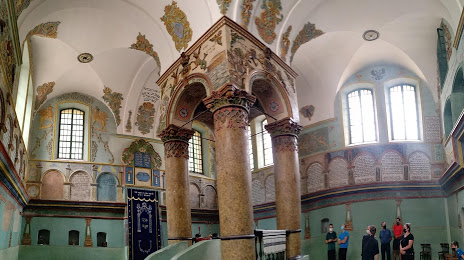
Photo
Where is located Łańcut Synagogue
Łańcut Synagogue — local attraction, which is located at plac Sobieskiego 16, 37-100 Łańcut, Poland and belongs to the category — synagogue. Average visitor rating for this place — 4.3 (according to 112 ratings, information from open sources and relevant for 2022).
Exact location — Łańcut Synagogue, marked on the map with a red marker.
You can get directions to Łańcut Synagogue on the map from your location.
What else is interesting in Lancut? You can see all the sights if you go to the city page.
Coordinates
Łańcut Synagogue, Poland coordinates in decimal format: latitude — 50.06753458941719, longitude — 22.231761125266992. When converted to degrees, minutes, seconds Łańcut Synagogue has the following coordinates: 50°4′3.12 north latitude and 22°13′54.34 east longitude.
Nearby cities
The largest cities that are located nearby:
- Rzeszow — 17 km
- Tarnow — 89 km
- Lublin — 132 km
- Kielce — 142 km
- Uzhhorod
 (Ukraine) — 160 km
 - Kraków — 162 km
- Košice
 (Slovakia) — 165 km
 - Radom — 165 km
- Dabrowa Gornicza — 216 km
- Sosnowiec — 222 km
- Katowice — 228 km
- Bielsko-Biala — 228 km
- Częstochowa — 232 km
- Chorzow — 233 km
- Bytom — 236 km
- Nyíregyháza
 (Hungary) — 237 km
 - Ruda Slaska — 239 km
- Miskolc (Hungary) — 243 km
- Zabrze — 245 km
Distance to the capital
Distance to the capital (Warsaw) is about — 255 km.