
 Puerto de la Duquesa
La Serna de Iguña
Pumalverde
Puentenansa
La Iglesia
Casar de Periedo
Fuengirola
Renedo de Piélagos
Villabanez
Puerto de la Duquesa
La Serna de Iguña
Pumalverde
Puentenansa
La Iglesia
Casar de Periedo
Fuengirola
Renedo de Piélagos
Villabanez
Castillo de Los Molares on the map, Utrera, Spain
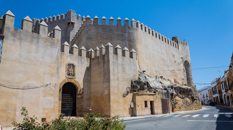
Photo
Where is located Castillo de Los Molares
Castillo de Los Molares — local attraction, which is located at C. Duque de Alcala, 2, 41750 Los Molares, Sevilla, Spain and belongs to the category — castle. Average visitor rating for this place — 4.2 (according to 177 ratings, information from open sources and relevant for 2022).
Exact location — Castillo de Los Molares, marked on the map with a red marker.
You can get directions to Castillo de Los Molares on the map from your location.
What else is interesting in Utrera? You can see all the sights if you go to the city page.
Coordinates
Castillo de Los Molares, Spain coordinates in decimal format: latitude — 37.33186996437757, longitude — -5.846589826334398. When converted to degrees, minutes, seconds Castillo de Los Molares has the following coordinates: 37°19′54.73 north latitude and -5°50′47.72 east longitude.
Nearby cities
The largest cities that are located nearby:
- Dos Hermanas — 17 km
- Jerez — 63 km
- Cádiz — 86 km
- Huelva — 103 km
- Marbella — 109 km
- Córdoba — 117 km
- Algeciras — 119 km
- Málaga — 128 km
- Tangier
 (Morocco) — 158 km
 - Tetouan (Morocco) — 183 km
- Jaén — 186 km
- Granada — 192 km
- Badajoz — 214 km
- Almería — 296 km
- Taounate (Morocco) — 311 km
- Kenitra (Morocco) — 333 km
- Lisbon
 (Portugal) — 336 km
 - Nador (Morocco) — 341 km
- Amadora (Portugal) — 344 km
Distance to the capital
Distance to the capital (Madrid) is about — 390 km.