
 Puerto de la Duquesa
La Serna de Iguña
Pumalverde
Puentenansa
La Iglesia
Casar de Periedo
Fuengirola
Renedo de Piélagos
Villabanez
Puerto de la Duquesa
La Serna de Iguña
Pumalverde
Puentenansa
La Iglesia
Casar de Periedo
Fuengirola
Renedo de Piélagos
Villabanez
Bañizuela Forest on the map, Jaén, Spain
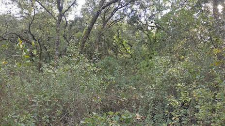
Photo
Where is located Bañizuela Forest
Bañizuela Forest — local attraction, which is located at 23640 Torredelcampo, Jaén, Spain and belongs to the category — tourist attraction. Average visitor rating for this place — 4.4 (according to 44 ratings, information from open sources and relevant for 2022).
Exact location — Bañizuela Forest, marked on the map with a red marker.
You can get directions to Bañizuela Forest on the map from your location.
What else is interesting in Jaén? You can see all the sights if you go to the city page.
Coordinates
Bañizuela Forest, Spain coordinates in decimal format: latitude — 37.756307908723116, longitude — -3.897215175133477. When converted to degrees, minutes, seconds Bañizuela Forest has the following coordinates: 37°45′22.71 north latitude and -3°53′49.97 east longitude.
Nearby cities
The largest cities that are located nearby:
- Granada — 69 km
- Córdoba — 88 km
- Málaga — 130 km
- Almería — 157 km
- Marbella — 171 km
- Dos Hermanas — 196 km
- Albacete — 213 km
- Murcia — 232 km
- Algeciras — 235 km
- Jerez — 240 km
- Cartagena — 245 km
- Cádiz — 262 km
- Fuenlabrada — 278 km
- Getafe — 280 km
- Móstoles — 281 km
- Leganés — 282 km
- Tetouan
 (Morocco) — 283 km
 - Alcorcón — 284 km
- Huelva — 284 km
Distance to the capital
Distance to the capital (Madrid) is about — 296 km.