
 Józefów nad Wisłą
Gorzyce Wielkie
Rogówek
Sromowce Niżne
Wyszków County
Kruszewo
Jantar
Sady Górne
Nagoszewo
Józefów nad Wisłą
Gorzyce Wielkie
Rogówek
Sromowce Niżne
Wyszków County
Kruszewo
Jantar
Sady Górne
Nagoszewo
Ruina pałacu w Siedlcach on the map, Lubin, Poland
Photo
Where is located Ruina pałacu w Siedlcach
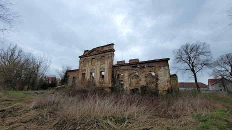
Ruina pałacu w Siedlcach — local attraction, which is located at 59-300 Siedlce, Poland and belongs to the category — castle. Average visitor rating for this place — 3.5 (according to 19 ratings, information from open sources and relevant for 2022).
Exact location — Ruina pałacu w Siedlcach, marked on the map with a red marker.
You can get directions to Ruina pałacu w Siedlcach on the map from your location.
What else is interesting in Lubin? You can see all the sights if you go to the city page.
Coordinates
Ruina pałacu w Siedlcach, Poland coordinates in decimal format: latitude — 51.39744465718639, longitude — 16.304941625315394. When converted to degrees, minutes, seconds Ruina pałacu w Siedlcach has the following coordinates: 51°23′50.8 north latitude and 16°18′17.79 east longitude.
Nearby cities
The largest cities that are located nearby:
- Legnica — 22 km
- Wrocław — 67 km
- Walbrzych — 69 km
- Zielona Gora — 75 km
- Poznań — 121 km
- Cottbus
 (Germany) — 133 km
 - Kalisz — 136 km
- Opole — 145 km
- Gorzów Wielkopolski — 160 km
- Dresden (Germany) — 175 km
- Prague
 (Czech Republic) — 193 km
 - Gliwice — 214 km
- Olomouc (Czech Republic) — 214 km
- Częstochowa — 215 km
- Zabrze — 218 km
- Rybnik — 220 km
- Berlin (Germany) — 224 km
- Berlin (Germany) — 225 km
- Bytom — 225 km
Distance to the capital
Distance to the capital (Warsaw) is about — 337 km.