
 Puerto de la Duquesa
La Serna de Iguña
Pumalverde
Puentenansa
La Iglesia
Casar de Periedo
Fuengirola
Renedo de Piélagos
Villabanez
Puerto de la Duquesa
La Serna de Iguña
Pumalverde
Puentenansa
La Iglesia
Casar de Periedo
Fuengirola
Renedo de Piélagos
Villabanez
Castillo de Benalí on the map, Onda, Spain
Photo
Where is located Castillo de Benalí
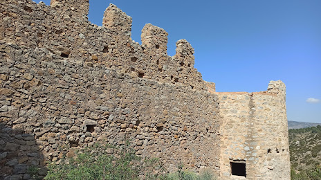
Castillo de Benalí — local attraction, which is located at no data and belongs to the category — -. Average visitor rating for this place — 4.4 (according to 31 rating, information from open sources and relevant for 2022).
Exact location — Castillo de Benalí, marked on the map with a red marker.
You can get directions to Castillo de Benalí on the map from your location.
What else is interesting in Onda? You can see all the sights if you go to the city page.
Coordinates
Castillo de Benalí, Spain coordinates in decimal format: latitude — 40.0924652451022, longitude — -0.1972079750645085. When converted to degrees, minutes, seconds Castillo de Benalí has the following coordinates: 40°5′32.87 north latitude and -0°11′49.95 east longitude.
Nearby cities
The largest cities that are located nearby:
- Valencia — 56 km
- Albacete — 174 km
- Tarragona — 179 km
- Zaragoza — 193 km
- Lleida — 197 km
- Murcia — 231 km
- L'Hospitalet de Llobregat — 251 km
- Palma — 252 km
- Terrassa — 258 km
- Santa Coloma de Gramenet — 262 km
- Sabadell — 263 km
- Badalona — 265 km
- Cartagena — 267 km
- Alcala de Henares — 267 km
- Torrejón de Ardoz — 276 km
- Mataró — 284 km
- Alcobendas — 291 km
- Getafe — 295 km
- Leganés — 298 km
Distance to the capital
Distance to the capital (Madrid) is about — 300 km.