
 Bel-Ha
San Jose El Alto
El Porvenir
Nueva Palestina
Santa Lucía
Chemax
La Morita
Temoac
Zacualpan
Bel-Ha
San Jose El Alto
El Porvenir
Nueva Palestina
Santa Lucía
Chemax
La Morita
Temoac
Zacualpan
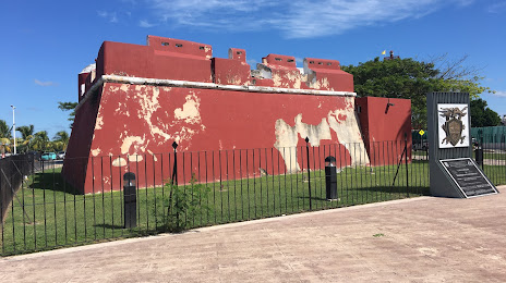
Baluarte de San Antonio on the map, Champoton, Mexico
Photo
Where is located Baluarte de San Antonio
Baluarte de San Antonio — local attraction, which is located at Malecón, 24400 Champoton, Campeche, Mexico and belongs to the category — museum. Average visitor rating for this place — 4.0 (according to 12 ratings, information from open sources and relevant for 2022).
Exact location — Baluarte de San Antonio, marked on the map with a red marker.
You can get directions to Baluarte de San Antonio on the map from your location.
What else is interesting in Champoton? You can see all the sights if you go to the city page.
Coordinates
Baluarte de San Antonio, Mexico coordinates in decimal format: latitude — 19.357600036513425, longitude — -90.72487667554506. When converted to degrees, minutes, seconds Baluarte de San Antonio has the following coordinates: 19°21′27.36 north latitude and -90°43′29.56 east longitude.
Nearby cities
The largest cities that are located nearby:
- Campeche — 57 km
- Ciudad del Carmen — 138 km
- Merida — 214 km
- Chetumal — 271 km
- Villahermosa — 278 km
- San Cristóbal de las Casas — 353 km
- Tuxtla Gutiérrez — 382 km
- Coatzacoalcos — 415 km
- Minatitlán — 430 km
- Cancún — 446 km
- Quetzaltenango
 (Guatemala) — 506 km
 - Choloma
 (Honduras) — 509 km
 - San Juan Sacatepéquez (Guatemala) — 512 km
- San Pedro Sula (Honduras) — 513 km
- Tapachula — 518 km
- Guatemala City (Guatemala) — 524 km
- Villa Nueva (Guatemala) — 533 km
- El Progreso (Honduras) — 536 km
- Villa Canales (Guatemala) — 539 km
Distance to the capital
Distance to the capital (Mexico City) is about — 882 km.