
 Litoral Del Bajo San Juan
El Cantón de San Pablo
Juan Frío
Santa Barbara
El Juncal
Dibulla
Vereda Campo Alegre
San Pablo
Guaramito
Litoral Del Bajo San Juan
El Cantón de San Pablo
Juan Frío
Santa Barbara
El Juncal
Dibulla
Vereda Campo Alegre
San Pablo
Guaramito
Glorieta La Pilonera Mayor on the map, Valledupar, Colombia
Photo
Where is located Glorieta La Pilonera Mayor
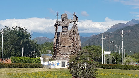
Glorieta La Pilonera Mayor — local attraction, which is located at Valledupar, Cesar, Colombia and belongs to the category — monument. Average visitor rating for this place — 4.6 (according to 510 ratings, information from open sources and relevant for 2022).
Exact location — Glorieta La Pilonera Mayor, marked on the map with a red marker.
You can get directions to Glorieta La Pilonera Mayor on the map from your location.
What else is interesting in Valledupar? You can see all the sights if you go to the city page.
Coordinates
Glorieta La Pilonera Mayor, Colombia coordinates in decimal format: latitude — 10.496756820705055, longitude — -73.26904707565225. When converted to degrees, minutes, seconds Glorieta La Pilonera Mayor has the following coordinates: 10°29′48.32 north latitude and -73°16′8.57 east longitude.
Nearby cities
The largest cities that are located nearby:
- Santa Marta — 134 km
- Maicao — 148 km
- Malambo — 171 km
- Soledad — 172 km
- Barranquilla — 176 km
- Maracaibo
 (Venezuela) — 177 km
 - Cabimas (Venezuela) — 194 km
- Magangué — 213 km
- Cartagena — 248 km
- Sincelejo — 268 km
- Cúcuta — 298 km
- Ejido (Venezuela) — 306 km
- Merida (Venezuela) — 309 km
- San Cristobal (Venezuela) — 319 km
- Monteria — 345 km
- Setpoint (Venezuela) — 359 km
- Bucaramanga — 370 km
- Giron — 377 km
- Floridablanca — 378 km
Distance to the capital
Distance to the capital (Bogota) is about — 662 km.