
 Manuel María Caballero
Santa Cruz Department
Pozo del Tigre
Motacucito
Colquiri
Inquisivi
Provincia de Andrés Ibáñez
Yacuíba
Tarija
Manuel María Caballero
Santa Cruz Department
Pozo del Tigre
Motacucito
Colquiri
Inquisivi
Provincia de Andrés Ibáñez
Yacuíba
Tarija
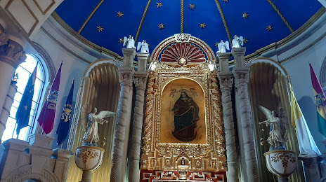
SANTUARIO DE LA VIRGEN DEL SOCAVON on the map, Oruro, Bolivia
Photo
Where is located SANTUARIO DE LA VIRGEN DEL SOCAVON
SANTUARIO DE LA VIRGEN DEL SOCAVON — local attraction, which is located at Oruro, Bolivia and belongs to the category — church. Average visitor rating for this place — 4.7 (according to 543 ratings, information from open sources and relevant for 2022).
Exact location — SANTUARIO DE LA VIRGEN DEL SOCAVON, marked on the map with a red marker.
You can get directions to SANTUARIO DE LA VIRGEN DEL SOCAVON on the map from your location.
What else is interesting in Oruro? You can see all the sights if you go to the city page.
Coordinates
SANTUARIO DE LA VIRGEN DEL SOCAVON, Bolivia coordinates in decimal format: latitude — -17.96750531297496, longitude — -67.11902877556592. When converted to degrees, minutes, seconds SANTUARIO DE LA VIRGEN DEL SOCAVON has the following coordinates: -17°58′3.02 north latitude and -67°7′8.5 east longitude.
Nearby cities
The largest cities that are located nearby:
- Cochabamba — 119 km
- Sucre — 226 km
- Potosi — 227 km
- Tacna
 (Peru) — 329 km
 - Arica
 (Chile) — 340 km
 - Fist (Peru) — 388 km
- Iquique (Chile) — 401 km
- Juliaca (Peru) — 421 km
- Santa Cruz de la Sierra — 433 km
- Tarija — 464 km
- Arequipa (Peru) — 499 km
- Calama (Chile) — 529 km
- Antofagasta (Chile) — 711 km
- San Salvador de Jujuy
 (Argentina) — 712 km
 - Cusco (Peru) — 716 km
- Salta (Argentina) — 773 km
- White River
 (Brazil) — 887 km
 - Ayacucho (Peru) — 931 km
- San Miguel de Tucuman (Argentina) — 995 km
Distance to the capital
Distance to the capital (Nuestra Señora de La Paz) is about — 197 km.