
 Belém
Maranguape
Paranaguá
Paranaguá
Monte Alegre
Alvorada de Minas
Bragança
Laguna
Ibiporã
Belém
Maranguape
Paranaguá
Paranaguá
Monte Alegre
Alvorada de Minas
Bragança
Laguna
Ibiporã
Lago Municipal de Palotina on the map, Palotina, Brazil
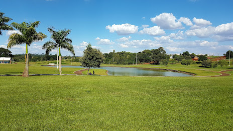
Photo
Where is located Lago Municipal de Palotina
Lago Municipal de Palotina — local attraction, which is located at no data and belongs to the category — -. Average visitor rating for this place — 4.8 (according to 41 rating, information from open sources and relevant for 2022).
Exact location — Lago Municipal de Palotina, marked on the map with a red marker.
You can get directions to Lago Municipal de Palotina on the map from your location.
What else is interesting in Palotina? You can see all the sights if you go to the city page.
Coordinates
Lago Municipal de Palotina, Brazil coordinates in decimal format: latitude — -24.28871259058015, longitude — -53.831519875458895. When converted to degrees, minutes, seconds Lago Municipal de Palotina has the following coordinates: -24°17′19.37 north latitude and -53°49′53.47 east longitude.
Nearby cities
The largest cities that are located nearby:
- Cascavel — 84 km
- Foz do Iguaçu — 156 km
- Ciudad del Este
 (Paraguay) — 157 km
 - Maringá — 215 km
- Dourados — 249 km
- Apucarana — 254 km
- Guarapuava — 267 km
- Chapecó — 334 km
- Presidente Prudente — 346 km
- Capiata (Paraguay) — 381 km
- Luque (Paraguay) — 381 km
- San Lorenzo (Paraguay) — 386 km
- Fernando De La Mora (Paraguay) — 389 km
- Assis — 392 km
- Lambare (Paraguay) — 395 km
- Asuncion (Paraguay) — 396 km
- Posadas
 (Argentina) — 396 km
 - Campo Grande — 429 km
- Marília — 458 km