
 Litoral Del Bajo San Juan
El Cantón de San Pablo
Juan Frío
Santa Barbara
El Juncal
Dibulla
Vereda Campo Alegre
San Pablo
Guaramito
Litoral Del Bajo San Juan
El Cantón de San Pablo
Juan Frío
Santa Barbara
El Juncal
Dibulla
Vereda Campo Alegre
San Pablo
Guaramito
La Piscinita on the map, San Andres, Colombia
Photo
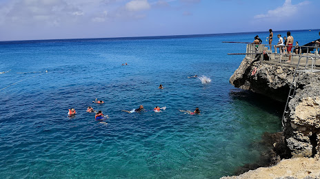
Where is located La Piscinita
La Piscinita — local attraction, which is located at 01, San Andrés, San Andrés y Providencia, Colombia and belongs to the category — tourist attraction. Average visitor rating for this place — 4.5 (according to 1075 ratings, information from open sources and relevant for 2022).
Exact location — La Piscinita, marked on the map with a red marker.
You can get directions to La Piscinita on the map from your location.
What else is interesting in San Andres? You can see all the sights if you go to the city page.
Coordinates
La Piscinita, Colombia coordinates in decimal format: latitude — 12.520022159473898, longitude — -81.72864087563326. When converted to degrees, minutes, seconds La Piscinita has the following coordinates: 12°31′12.08 north latitude and -81°43′43.11 east longitude.
Nearby cities
The largest cities that are located nearby:
- San Jose
 (Costa Rica) — 392 km
 - San Miguelito
 (Panama) — 458 km
 - Panama (Panama) — 464 km
- Masaya
 (Nicaragua) — 479 km
 - Managua (Nicaragua) — 494 km
- Lion (Nicaragua) — 558 km
- Chinandega (Nicaragua) — 585 km
- Tegucigalpa
 (Honduras) — 614 km
 - La Ceiba (Honduras) — 649 km
- San Miguel
 (El Salvador) — 703 km
 - Cartagena — 713 km
- El Progreso (Honduras) — 721 km
- Choloma (Honduras) — 743 km
- San Pedro Sula (Honduras) — 747 km
- Monteria — 764 km
- Barranquilla — 771 km
- Soledad — 775 km
- Malambo — 776 km
- Sincelejo — 778 km
Distance to the capital
Distance to the capital (Bogota) is about — 1218 km.