
 Belém
Maranguape
Paranaguá
Paranaguá
Monte Alegre
Alvorada de Minas
Bragança
Laguna
Ibiporã
Belém
Maranguape
Paranaguá
Paranaguá
Monte Alegre
Alvorada de Minas
Bragança
Laguna
Ibiporã
Parque Natural Municipal Morro do Baú on the map, Ilhota, Brazil
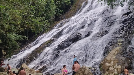
Photo
Where is located Parque Natural Municipal Morro do Baú
Parque Natural Municipal Morro do Baú — local attraction, which is located at Estrada Geral Auto Baú, s/n - Alto Baú, Ilhota - SC, 88320-000, Brazil and belongs to the category — wildlife park. Average visitor rating for this place — 4.6 (according to 226 ratings, information from open sources and relevant for 2022).
Exact location — Parque Natural Municipal Morro do Baú, marked on the map with a red marker.
You can get directions to Parque Natural Municipal Morro do Baú on the map from your location.
What else is interesting in Ilhota? You can see all the sights if you go to the city page.
Coordinates
Parque Natural Municipal Morro do Baú, Brazil coordinates in decimal format: latitude — -26.805339374983696, longitude — -48.953354475407856. When converted to degrees, minutes, seconds Parque Natural Municipal Morro do Baú has the following coordinates: -26°48′19.22 north latitude and -48°57′12.08 east longitude.
Nearby cities
The largest cities that are located nearby:
- Itajaí — 15 km
- Blumenau — 24 km
- Jaraguá do Sul — 53 km
- Joinville — 66 km
- São José — 81 km
- Florianópolis — 81 km
- Palhoça — 84 km
- São José dos Pinhais — 156 km
- Paranaguá — 156 km
- Araucária — 157 km
- Pinhais — 165 km
- Curitiba — 169 km
- Lages — 178 km
- Colombo — 182 km
- Criciúma — 203 km
- Guarapuava — 312 km
- Caxias do Sul — 338 km
- Chapecó — 374 km
- Itapetininga — 375 km