
 Puerto de la Duquesa
La Serna de Iguña
Pumalverde
Puentenansa
La Iglesia
Casar de Periedo
Fuengirola
Renedo de Piélagos
Villabanez
Puerto de la Duquesa
La Serna de Iguña
Pumalverde
Puentenansa
La Iglesia
Casar de Periedo
Fuengirola
Renedo de Piélagos
Villabanez
Cala Illa Mateua on the map, L'Escala, Spain
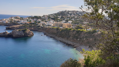
Photo
Where is located Cala Illa Mateua
Cala Illa Mateua — local attraction, which is located at Carrer Punta Montgó, 57, 17130 L'Escala, Girona, Spain and belongs to the category — public beach. Average visitor rating for this place — 4.6 (according to 347 ratings, information from open sources and relevant for 2022).
Exact location — Cala Illa Mateua, marked on the map with a red marker.
You can get directions to Cala Illa Mateua on the map from your location.
What else is interesting in L'Escala? You can see all the sights if you go to the city page.
Coordinates
Cala Illa Mateua, Spain coordinates in decimal format: latitude — 42.11284586405582, longitude — 3.165104824997922. When converted to degrees, minutes, seconds Cala Illa Mateua has the following coordinates: 42°6′46.25 north latitude and 3°9′54.38 east longitude.
Nearby cities
The largest cities that are located nearby:
- Perpignan
 (France) — 67 km
 - Mataró — 86 km
- Badalona — 104 km
- Sabadell — 106 km
- Santa Coloma de Gramenet — 107 km
- Terrassa — 112 km
- L'Hospitalet de Llobregat — 118 km
- Montpellier (France) — 176 km
- Tarragona — 192 km
- Toulouse (France) — 214 km
- Nimes (France) — 214 km
- Lleida — 216 km
- Marseille (France) — 222 km
- Aix-en-Provence (France) — 242 km
- Toulon (France) — 251 km
- Palma — 284 km
- Zaragoza — 337 km
- Nice (France) — 374 km
- Saint-Étienne (France) — 381 km
Distance to the capital
Distance to the capital (Madrid) is about — 604 km.