
 Puerto de la Duquesa
La Serna de Iguña
Pumalverde
Puentenansa
La Iglesia
Casar de Periedo
Fuengirola
Renedo de Piélagos
Villabanez
Puerto de la Duquesa
La Serna de Iguña
Pumalverde
Puentenansa
La Iglesia
Casar de Periedo
Fuengirola
Renedo de Piélagos
Villabanez
Casa de Juntas de Gernika - Gernikako Batzarretxea on the map, Gernika-Lumo, Spain
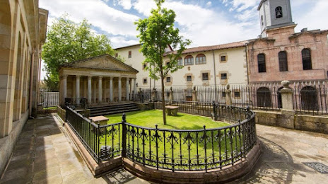
Photo
Where is located Casa de Juntas de Gernika - Gernikako Batzarretxea
Casa de Juntas de Gernika - Gernikako Batzarretxea — local attraction, which is located at Karmelo Etxegarai Kalea, 11, 48300 Gernika-Lumo, Bizkaia, Spain and belongs to the category — cultural center. Average visitor rating for this place — 4.5 (according to 2937 ratings, information from open sources and relevant for 2022).
Exact location — Casa de Juntas de Gernika - Gernikako Batzarretxea, marked on the map with a red marker.
You can get directions to Casa de Juntas de Gernika - Gernikako Batzarretxea on the map from your location.
What else is interesting in Gernika-Lumo? You can see all the sights if you go to the city page.
Coordinates
Casa de Juntas de Gernika - Gernikako Batzarretxea, Spain coordinates in decimal format: latitude — 43.313174550063984, longitude — -2.6796841749638443. When converted to degrees, minutes, seconds Casa de Juntas de Gernika - Gernikako Batzarretxea has the following coordinates: 43°18′47.43 north latitude and -2°40′46.86 east longitude.
Nearby cities
The largest cities that are located nearby:
- Bilbao — 21 km
- Vitoria-Gasteiz — 50 km
- San Sebastián — 56 km
- Santander — 92 km
- Logroño — 96 km
- Pamplona — 100 km
- Burgos — 135 km
- Bordeaux
 (France) — 236 km
 - Zaragoza — 236 km
- Gijón — 240 km
- León — 248 km
- Valladolid — 249 km
- Oviedo — 255 km
- Alcobendas — 317 km
- Alcala de Henares — 318 km
- Torrejón de Ardoz — 323 km
- Lleida — 331 km
- Toulouse (France) — 332 km
- Alcorcón — 342 km
Distance to the capital
Distance to the capital (Madrid) is about — 333 km.