
 Litoral Del Bajo San Juan
El Cantón de San Pablo
Juan Frío
Santa Barbara
El Juncal
Dibulla
Vereda Campo Alegre
San Pablo
Guaramito
Litoral Del Bajo San Juan
El Cantón de San Pablo
Juan Frío
Santa Barbara
El Juncal
Dibulla
Vereda Campo Alegre
San Pablo
Guaramito
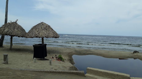
Puerto Viejo - Coveñas on the map, Tolu, Colombia
Photo
Where is located Puerto Viejo - Coveñas
Puerto Viejo - Coveñas — local attraction, which is located at no data and belongs to the category — -. Average visitor rating for this place — 4.4 (according to 206 ratings, information from open sources and relevant for 2022).
Exact location — Puerto Viejo - Coveñas, marked on the map with a red marker.
You can get directions to Puerto Viejo - Coveñas on the map from your location.
What else is interesting in Tolu? You can see all the sights if you go to the city page.
Coordinates
Puerto Viejo - Coveñas, Colombia coordinates in decimal format: latitude — 9.468185639668471, longitude — -75.6079525541243. When converted to degrees, minutes, seconds Puerto Viejo - Coveñas has the following coordinates: 9°28′5.47 north latitude and -75°36′28.63 east longitude.
Nearby cities
The largest cities that are located nearby:
- Sincelejo — 31 km
- Monteria — 93 km
- Magangué — 95 km
- Cartagena — 98 km
- Malambo — 171 km
- Soledad — 176 km
- Barranquilla — 180 km
- Santa Marta — 240 km
- Valledupar — 273 km
- Barrancabermeja — 332 km
- Bello — 353 km
- Medellín — 360 km
- Envigado — 371 km
- Itagüi — 372 km
- Bucaramanga — 377 km
- Giron — 378 km
- Cúcuta — 382 km
- Floridablanca — 385 km
- San Cristobal
 (Venezuela) — 415 km
Distance to the capital
Distance to the capital (Bogota) is about — 567 km.