
 La Armonía
Timote
Cruz de Piedra
Villa Concepción del Tio
Manantiales
Colonia Italiana
Los Tigres
Puerto Leoni
Campo Santo
La Armonía
Timote
Cruz de Piedra
Villa Concepción del Tio
Manantiales
Colonia Italiana
Los Tigres
Puerto Leoni
Campo Santo
Soberanía Park on the map, Jardín América, Argentina
Photo
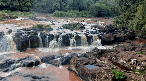
Where is located Soberanía Park
Soberanía Park — local attraction, which is located at no data and belongs to the category — -. Average visitor rating for this place — 4.5 (according to 3054 ratings, information from open sources and relevant for 2022).
Exact location — Soberanía Park, marked on the map with a red marker.
You can get directions to Soberanía Park on the map from your location.
What else is interesting in Jardín América? You can see all the sights if you go to the city page.
Coordinates
Soberanía Park, Argentina coordinates in decimal format: latitude — -27.05147548094932, longitude — -55.22815927540271. When converted to degrees, minutes, seconds Soberanía Park has the following coordinates: -27°3′5.31 north latitude and -55°13′41.37 east longitude.
Nearby cities
The largest cities that are located nearby:
- Posadas — 75 km
- Ciudad del Este
 (Paraguay) — 179 km
 - Foz do Iguaçu
 (Brazil) — 181 km
 - Chapecó (Brazil) — 257 km
- Capiata (Paraguay) — 289 km
- Cascavel (Brazil) — 291 km
- San Lorenzo (Paraguay) — 297 km
- Luque (Paraguay) — 299 km
- Fernando De La Mora (Paraguay) — 300 km
- Lambare (Paraguay) — 303 km
- Passo Fundo (Brazil) — 305 km
- Formosa — 308 km
- Asuncion (Paraguay) — 310 km
- Santa Maria (Brazil) — 322 km
- Uruguaiana (Brazil) — 350 km
- Corrientes — 358 km
- Resistencia — 372 km
- Santa Cruz do Sul (Brazil) — 400 km
- Guarapuava (Brazil) — 418 km
Distance to the capital
Distance to the capital (Buenos Aires) is about — 892 km.