
 Belém
Maranguape
Paranaguá
Paranaguá
Monte Alegre
Alvorada de Minas
Bragança
Laguna
Ibiporã
Belém
Maranguape
Paranaguá
Paranaguá
Monte Alegre
Alvorada de Minas
Bragança
Laguna
Ibiporã
Praia Grande de Salvaterra on the map, Salvaterra, Brazil
Photo
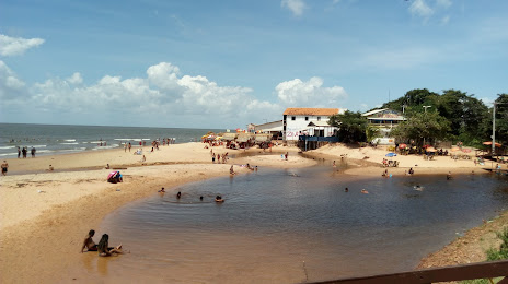
Where is located Praia Grande de Salvaterra
Praia Grande de Salvaterra — local attraction, which is located at no data and belongs to the category — -. Average visitor rating for this place — 4.5 (according to 898 ratings, information from open sources and relevant for 2022).
Exact location — Praia Grande de Salvaterra, marked on the map with a red marker.
You can get directions to Praia Grande de Salvaterra on the map from your location.
What else is interesting in Salvaterra? You can see all the sights if you go to the city page.
Coordinates
Praia Grande de Salvaterra, Brazil coordinates in decimal format: latitude — -0.7647339929241511, longitude — -48.51148028509814. When converted to degrees, minutes, seconds Praia Grande de Salvaterra has the following coordinates: -0°45′53.04 north latitude and -48°30′41.33 east longitude.
Nearby cities
The largest cities that are located nearby:
- Ananindeua — 69 km
- Belém — 77 km
- Castanhal — 89 km
- Macapá — 296 km
- São Luís — 507 km
- Marabá — 516 km
- Imperatriz — 539 km
- Santarém — 709 km
- Araguaína — 712 km
- Caxias — 727 km
- Parnaíba — 781 km
- Timon — 788 km
- Teresina — 791 km
- Paramaribo
 (Suriname) — 1037 km
 - Palmas — 1049 km
- Caucaia — 1135 km
- Maracanaú — 1144 km
- Fortaleza — 1150 km
- Juazeiro do Norte — 1237 km