Houghton Estate — Frankfort
Houghton Estate — Roodepoort
Houghton Estate — Ramsgate
Houghton Estate — Graskop
Houghton Estate — Orkney
Houghton Estate — Polokwane
Houghton Estate — Underberg
Houghton Estate — Ozwathini
Houghton Estate — South Africa
Houghton Estate — Normandien
Houghton Estate — Uitzicht
Houghton Estate — Struis Bay
Houghton Estate — Swartkop
Houghton Estate — Mowbray
Houghton Estate — Jongensfontein
Houghton Estate — Hlanganani
Houghton Estate — Ladysmith
Houghton Estate — Newlands
Houghton Estate — Mkuze
Melville
Johannesburg
Turffontein
Diepkloof
Pimville
Zakariyya Park
Grasmere
Evaton
Sebokeng
ArcelorMittal Vanderbijlpark Works
Parys
Riastuine AH
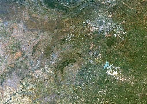
Houghton Estate — Vredefort distance, route on the map
Distance by car
Distance between Houghton Estate, Gauteng, South Africa and Vredefort, Free State, South Africa by car is — km, or miles. To travel this distance by car, you need minute, or h.
Route on the map, driving directions
Car route Houghton Estate — Vredefort was created automatically. The road on the map is shown as a blue line. By moving the markers, you can create a new route through the points you need.
Passing cities through which the car route passes: Parkview, Melville, Johannesburg, Turffontein, Diepkloof, Pimville, Zakariyya Park, Grasmere, Evaton, Sebokeng, ArcelorMittal Vanderbijlpark Works, Parys, Riastuine AH.
Distance by plane
If you decide to take a trip Houghton Estate Vredefort by plane, then you have to fly the distance — 116 km or 72 miles. It is marked on the map with a gray line (between two points in a straight line).
Flight time
Estimated flight time Houghton Estate Vredefort by plane at cruising speed 750 km / h will be — 9 min.
Direction of movement
South Africa, Houghton Estate — left-hand traffic. South Africa, Vredefort — left-hand traffic.
Difference in time
Houghton Estate and Vredefort are in the same time zone. Between them there is no time difference (UTC +2 Africa/Johannesburg).
Interesting Facts
Information on alternative ways to get to your destination.
The length of this distance is about 0.3% of the total length of the equator.
The cost of travel
Calculate the cost of the trip yourself using the fuel consumption calculator, changing the data in the table.