
 Maureville
Samoëns
Gréning
Toulouse
Volx
Goudet
Méhoncourt
Saint-Hymer
Pontcarré
Maureville
Samoëns
Gréning
Toulouse
Volx
Goudet
Méhoncourt
Saint-Hymer
Pontcarré
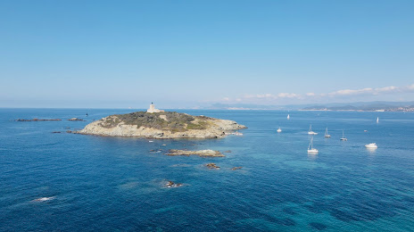
Île du Grand Rouveau on the map, Six-Fours-les-Plages, France
Photo
Where is located Île du Grand Rouveau
Île du Grand Rouveau — local attraction, which is located at no data and belongs to the category — -. Average visitor rating for this place — 4.7 (according to 21 rating, information from open sources and relevant for 2022).
Exact location — Île du Grand Rouveau, marked on the map with a red marker.
You can get directions to Île du Grand Rouveau on the map from your location.
What else is interesting in Six-Fours-les-Plages? You can see all the sights if you go to the city page.
Coordinates
Île du Grand Rouveau, France coordinates in decimal format: latitude — 43.080365009012176, longitude — 5.767095790307115. When converted to degrees, minutes, seconds Île du Grand Rouveau has the following coordinates: 43°4′49.31 north latitude and 5°46′1.54 east longitude.
Nearby cities
The largest cities that are located nearby:
- Toulon — 8 km
- Marseille — 44 km
- Aix-en-Provence — 58 km
- Nice — 133 km
- Nimes — 144 km
- Montpellier — 167 km
- Grenoble — 232 km
- Perpignan — 243 km
- Turin
 (Italy) — 262 km
 - Saint-Étienne — 283 km
- Genoa (Italy) — 285 km
- Villeurbanne — 305 km
- Lyon — 305 km
- Mataró
 (Spain) — 329 km
 - Novara (Italy) — 338 km
- Geneva
 (Switzerland) — 344 km
 - Sassari (Italy) — 347 km
- Badalona (Spain) — 349 km
- Santa Coloma de Gramenet (Spain) — 352 km
Distance to the capital
Distance to the capital (Paris) is about — 694 km.