
 Maureville
Samoëns
Gréning
Toulouse
Volx
Goudet
Méhoncourt
Saint-Hymer
Pontcarré
Maureville
Samoëns
Gréning
Toulouse
Volx
Goudet
Méhoncourt
Saint-Hymer
Pontcarré
Plage de Querqueville on the map, Cherbourg, France
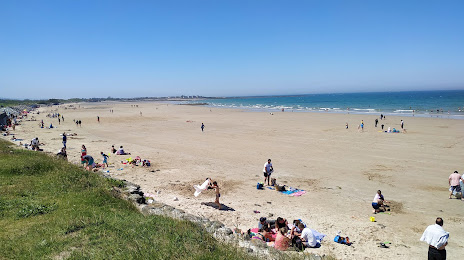
Photo
Where is located Plage de Querqueville
Plage de Querqueville — local attraction, which is located at Bd de la Hague, 50460 Cherbourg-en-Cotentin, France and belongs to the category — public bath. Average visitor rating for this place — 4.5 (according to 345 ratings, information from open sources and relevant for 2022).
Exact location — Plage de Querqueville, marked on the map with a red marker.
You can get directions to Plage de Querqueville on the map from your location.
What else is interesting in Cherbourg? You can see all the sights if you go to the city page.
Coordinates
Plage de Querqueville, France coordinates in decimal format: latitude — 49.67003103327378, longitude — -1.6999757747473077. When converted to degrees, minutes, seconds Plage de Querqueville has the following coordinates: 49°40′12.11 north latitude and -1°41′59.91 east longitude.
Nearby cities
The largest cities that are located nearby:
- Caen — 103 km
- Bournemouth
 (United Kingdom) — 121 km
 - Le Havre — 125 km
- Portsmouth (United Kingdom) — 136 km
- Southampton (United Kingdom) — 142 km
- Rennes — 168 km
- Exeter (United Kingdom) — 180 km
- Eastbourne (United Kingdom) — 183 km
- Crawley (United Kingdom) — 191 km
- Rouen — 197 km
- Reading (United Kingdom) — 206 km
- Bristol (Great Britain) — 212 km
- Swindon (United Kingdom) — 213 km
- Sutton (United Kingdom) — 215 km
- Slough (United Kingdom) — 219 km
- Le Mans — 225 km
- London (United Kingdom) — 231 km
- Oxford (United Kingdom) — 236 km
- Watford (United Kingdom) — 239 km
Distance to the capital
Distance to the capital (Paris) is about — 308 km.