
 Manuel María Caballero
Santa Cruz Department
Pozo del Tigre
Motacucito
Colquiri
Inquisivi
Provincia de Andrés Ibáñez
Yacuíba
Tarija
Manuel María Caballero
Santa Cruz Department
Pozo del Tigre
Motacucito
Colquiri
Inquisivi
Provincia de Andrés Ibáñez
Yacuíba
Tarija
Uturunku on the map, Uyuni, Bolivia
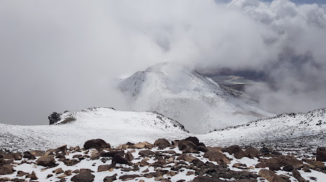
Photo
Where is located Uturunku
Uturunku — local attraction, which is located at 6,008 m and belongs to the category — -. Average visitor rating for this place — 4.4 (according to 21 rating, information from open sources and relevant for 2022).
Exact location — Uturunku, marked on the map with a red marker.
You can get directions to Uturunku on the map from your location.
What else is interesting in Uyuni? You can see all the sights if you go to the city page.
Coordinates
Uturunku, Bolivia coordinates in decimal format: latitude — -20.46384141928494, longitude — -66.82331657552736. When converted to degrees, minutes, seconds Uturunku has the following coordinates: -20°27′49.83 north latitude and -66°49′23.94 east longitude.
Nearby cities
The largest cities that are located nearby:
- Potosi — 149 km
- Sucre — 228 km
- Tarija — 246 km
- Oruro — 277 km
- Calama
 (Chile) — 308 km
 - Iquique (Chile) — 345 km
- Cochabamba — 347 km
- Arica (Chile) — 426 km
- San Salvador de Jujuy
 (Argentina) — 440 km
 - Tacna
 (Peru) — 450 km
 - Santa Cruz de la Sierra — 494 km
- Salta (Argentina) — 499 km
- Antofagasta (Chile) — 505 km
- Fist (Peru) — 614 km
- Juliaca (Peru) — 652 km
- Arequipa (Peru) — 671 km
- San Miguel de Tucuman (Argentina) — 720 km
- Copiapó (Chile) — 838 km
- Santiago del Estero (Argentina) — 848 km
Distance to the capital
Distance to the capital (Nuestra Señora de La Paz) is about — 463 km.