
 Maureville
Samoëns
Gréning
Toulouse
Volx
Goudet
Méhoncourt
Saint-Hymer
Pontcarré
Maureville
Samoëns
Gréning
Toulouse
Volx
Goudet
Méhoncourt
Saint-Hymer
Pontcarré
Les Rosaires on the map, Ploufragan, France
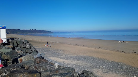
Photo
Where is located Les Rosaires
Les Rosaires — local attraction, which is located at no data and belongs to the category — -. Average visitor rating for this place — 4.4 (according to 2907 ratings, information from open sources and relevant for 2022).
Exact location — Les Rosaires, marked on the map with a red marker.
You can get directions to Les Rosaires on the map from your location.
What else is interesting in Ploufragan? You can see all the sights if you go to the city page.
Coordinates
Les Rosaires, France coordinates in decimal format: latitude — 48.564442419675224, longitude — -2.755814997800818. When converted to degrees, minutes, seconds Les Rosaires has the following coordinates: 48°33′51.99 north latitude and -2°45′20.93 east longitude.
Nearby cities
The largest cities that are located nearby:
- Rennes — 92 km
- Brest — 125 km
- Nantes — 169 km
- Caen — 191 km
- Angers — 201 km
- Le Mans — 228 km
- Le Havre — 236 km
- Exeter
 (United Kingdom) — 252 km
 - Bournemouth (United Kingdom) — 255 km
- Portsmouth (United Kingdom) — 284 km
- Southampton (United Kingdom) — 285 km
- Tours — 287 km
- Rouen — 299 km
- Bristol (Great Britain) — 328 km
- Eastbourne (United Kingdom) — 332 km
- Crawley (United Kingdom) — 342 km
- Swindon (United Kingdom) — 346 km
- Reading (United Kingdom) — 351 km
- Orléans — 355 km
Distance to the capital
Distance to the capital (Paris) is about — 376 km.