
 Maureville
Samoëns
Gréning
Toulouse
Volx
Goudet
Méhoncourt
Saint-Hymer
Pontcarré
Maureville
Samoëns
Gréning
Toulouse
Volx
Goudet
Méhoncourt
Saint-Hymer
Pontcarré
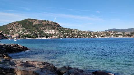
Plage de la Petite Fontaine on the map, Mandelieu-la-Napoule, France
Photo
Where is located Plage de la Petite Fontaine
Plage de la Petite Fontaine — local attraction, which is located at no data and belongs to the category — -. Average visitor rating for this place — 4.5 (according to 13 ratings, information from open sources and relevant for 2022).
Exact location — Plage de la Petite Fontaine, marked on the map with a red marker.
You can get directions to Plage de la Petite Fontaine on the map from your location.
What else is interesting in Mandelieu-la-Napoule? You can see all the sights if you go to the city page.
Coordinates
Plage de la Petite Fontaine, France coordinates in decimal format: latitude — 43.50577792433721, longitude — 6.946353191189765. When converted to degrees, minutes, seconds Plage de la Petite Fontaine has the following coordinates: 43°30′20.8 north latitude and 6°56′46.87 east longitude.
Nearby cities
The largest cities that are located nearby:
- Nice — 32 km
- Toulon — 94 km
- Aix-en-Provence — 120 km
- Marseille — 129 km
- Turin
 (Italy) — 178 km
 - Genoa (Italy) — 185 km
- Grenoble — 205 km
- Nimes — 208 km
- Montpellier — 245 km
- Novara (Italy) — 247 km
- Livorno (Italy) — 270 km
- Milan (Italy) — 275 km
- Saint-Étienne — 288 km
- Monza (Italy) — 289 km
- Villeurbanne — 292 km
- Lyon — 294 km
- Geneva
 (Switzerland) — 299 km
 - Parma (Italy) — 300 km
- Bergamo (Italy) — 318 km
Distance to the capital
Distance to the capital (Paris) is about — 692 km.