
 Józefów nad Wisłą
Gorzyce Wielkie
Rogówek
Sromowce Niżne
Wyszków County
Kruszewo
Jantar
Sady Górne
Nagoszewo
Józefów nad Wisłą
Gorzyce Wielkie
Rogówek
Sromowce Niżne
Wyszków County
Kruszewo
Jantar
Sady Górne
Nagoszewo
Regional Directorate of State Forests in Szczecinek on the map, Szczecinek, Poland
Photo
Where is located Regional Directorate of State Forests in Szczecinek
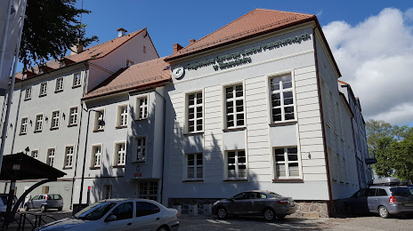
Regional Directorate of State Forests in Szczecinek — local attraction, which is located at Mickiewicza 2, 78-400 Szczecinek, Poland and belongs to the category — national forest. Average visitor rating for this place — 4.4 (according to 18 ratings, information from open sources and relevant for 2022).
Exact location — Regional Directorate of State Forests in Szczecinek, marked on the map with a red marker.
You can get directions to Regional Directorate of State Forests in Szczecinek on the map from your location.
What else is interesting in Szczecinek? You can see all the sights if you go to the city page.
Coordinates
Regional Directorate of State Forests in Szczecinek, Poland coordinates in decimal format: latitude — 53.706598402291995, longitude — 16.693525425401518. When converted to degrees, minutes, seconds Regional Directorate of State Forests in Szczecinek has the following coordinates: 53°42′23.75 north latitude and 16°41′36.69 east longitude.
Nearby cities
The largest cities that are located nearby:
- Koszalin — 63 km
- Bydgoszcz — 108 km
- Gdańsk — 144 km
- Szczecin — 145 km
- Poznań — 145 km
- Gorzów Wielkopolski — 146 km
- Gdynia — 148 km
- Torun — 148 km
- Elblag — 182 km
- Wloclawek — 198 km
- Zielona Gora — 212 km
- Kalisz — 235 km
- Plock — 240 km
- Olsztyn — 247 km
- Berlin
 (Germany) — 258 km
 - Berlin (Germany) — 260 km
- Kaliningrad
 (Russia) — 268 km
 - Cottbus (Germany) — 270 km
- Legnica — 279 km
Distance to the capital
Distance to the capital (Warsaw) is about — 333 km.