
 Puerto de la Duquesa
La Serna de Iguña
Pumalverde
Puentenansa
La Iglesia
Casar de Periedo
Fuengirola
Renedo de Piélagos
Villabanez
Puerto de la Duquesa
La Serna de Iguña
Pumalverde
Puentenansa
La Iglesia
Casar de Periedo
Fuengirola
Renedo de Piélagos
Villabanez
Parque de Carbayedo on the map, Aviles, Spain
Photo
Where is located Parque de Carbayedo
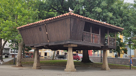
Parque de Carbayedo — local attraction, which is located at Plaza Carbayedo, 1, 33402 Avilés, Asturias, Spain and belongs to the category — city park. Average visitor rating for this place — 4.4 (according to 559 ratings, information from open sources and relevant for 2022).
Exact location — Parque de Carbayedo, marked on the map with a red marker.
You can get directions to Parque de Carbayedo on the map from your location.
What else is interesting in Aviles? You can see all the sights if you go to the city page.
Coordinates
Parque de Carbayedo, Spain coordinates in decimal format: latitude — 43.55343348924208, longitude — -5.927081774956073. When converted to degrees, minutes, seconds Parque de Carbayedo has the following coordinates: 43°33′12.36 north latitude and -5°55′37.49 east longitude.
Nearby cities
The largest cities that are located nearby:
- Gijón — 21 km
- Oviedo — 23 km
- León — 110 km
- Santander — 170 km
- A Coruña — 201 km
- Ourense — 208 km
- Burgos — 226 km
- Valladolid — 233 km
- Bilbao — 243 km
- Vigo — 271 km
- Vitoria-Gasteiz — 274 km
- Salamanca — 287 km
- Braga
 (Portugal) — 304 km
 - Logroño — 309 km
- San Sebastián — 318 km
- Porto (Portugal) — 348 km
- Pamplona — 357 km
- Alcobendas — 385 km
- Alcorcón — 397 km
Distance to the capital
Distance to the capital (Madrid) is about — 394 km.